Datarban is located approximately forty kilometers west of Samarinda. Ten to twenty kilometers to the north and east of the village, the muddy brown Mahakam River snakes through the once dense primary forests that covered the region. In the 1980s, this landscape was rapidly transformed as forests were cleared for logging, mining, plantation crops, and small farm holdings. A series of forest fires further reduced large areas of the forest ecosystem into scrub. Between 1982 and 1992, the expanding village of Datarban that had comprised eighty-two households at the beginning of the decade declined to thirty-two families. The community's stream has been contaminated by acid tailings from coal mining operations. Large commercial enterprises and government programs have claimed so much land that a sufficient area is no longer available for long-term rotational swidden agriculture. The low-fertility, overworked soils are increasingly invaded by alang alang grass (Imperata cylindrica), an indicator of declining fertility. This process of resource degradation appears common in areas of East Kalimantan where roads are being built and commercial development, combined with migrant pressures, is growing. Initial research indicates that these land-use systems are not only unsustainable, but also are leading to the rapid impoverishment of the area's natural and community resources, undermining biodiversity, human support potential, and economic benefit flows. This case examines the forces and patterns driving this process in an effort to derive alternative management Systems that better respond to the social, economic, and environmental needs of local communities and the nation.
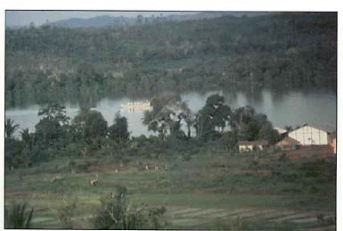
Sited along the lower Mahakam River, Tenggarong was the ancestral home of Kutai kings, whose descendants migrated to Datarban -- a population flow pattern which is now reversing
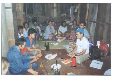
Village headman and other concerned residents of Datarban discuss with Network researchers their economic dependencies on the remaining forests and ideas for community forest protection and management
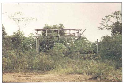
Responding to growing land-use pressure and resource degradation, two-thirds of the population of Datarban has migrated out of the area over recent years
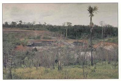
As one of numerous overlapping and poorly regulated land uses in Datarban, coal mining has caused both forest degradation and contamination of the local water resource
Prior to the 1950s, most of the land east of the Mahakam River and the ancient Kutai capital of Tenggarong was covered with primary forest. A coastal, Malay-speaking group that settled in the Mahakam River delta hundreds of years ago, the Kutai people hunted and collected non-timber forest products, including rattan, gahru, birds' nests, honey, and resins to the west and south of the river for centuries. Local Kutai communities were largely located along the river, where they practiced a rotational system of swamp rice cultivation and maintained tree gardens (kebun). By the 1950s, growing population pressures spurred Kutai farmers to move into the interior forest and open swidden (ladang) fields 10-20 kilometers from the river.
The process of land conversion was next accelerated at the outset of the manual logging boom, when a system called banjir kap was initiated by provincial entrepreneurs. Due to the growing international market for tropical hardwood timber, local operators began organizing Kutai and Dayak chainsaw workers to log trees 1-2 kilometers from the Mahakam's banks. Since no roads or heavy equipment were available, channels were dug to float the logs down to the river or to tributaries large enough to carry them. Water buffalo were often used to haul the logs to the channels. The banjir kap extraction system was brief and intense, practiced widely from only 1968 to 1971. In late 1971, the central government placed a ban on manual logging due both to objections from Japanese buyers over hand-cut logs and a desire to shift concession allocations from the provinces to Jakarta (
FN 10).In the early 1970s, the Indonesian government began leasing larger tracts of forest land to highly capitalized national or multinational timber operations. One of the first major timber companies to establish itself in the Samarinda-Balikpapan area was Weyerhauser in 1969. Later acquired by an Indonesian consortium and renamed P.T. ITCI, the 600,000-hectare concession is considered by the Ministry of Forestry to be one of the best managed in Indonesia. This is because the company has generally followed the logging guidelines issued by the government.
In 1974 Weyerhauser set up a base camp at Senoni in the Datarban study area and began building a network of truck roads through which timber could be removed. Simultaneously, in 1974 the government built a road connecting Samarinda to Tenggarong, linking the river cities with the interior forest areas. Weyerhauser selectively felled the Senoni area between 1978 and 1984, leaving behind a fairly extensive network of compacted dirt roads. Following these conduits to the interior, families of Benuaq Dayaks from Kecamatan Damai began settling in Datarban in 1983, joining the Kutai families that had arrived some years earlier. The Dayaks reportedly left Damai, 140 kilometers to the west up the Mahakam, to gain better access to markets where they could sell vegetables, fruits, and forest products. The need for cash was stimulated by a desire to educate their children, who had to travel downriver to Tenggarong or Samarinda to attend school above the primary level.
Pak Abraham, a Dayak elder and traditional chief (ketua suku) of the community in Datarban, explained that he had come to the Tenggarong area in 1978 to identify suitable land for families from Damai. He had originally opened swidden plots in Timbau near the river, but in 1982, he was evicted by a large cocoa and rubber plantation (Hasfarm) that was being established on a 15,000-hectare tract by a local entrepreneur. After moving to Datarban, Pak Abraham began opening swidden fields, hunting and gathering forest products on P.T. ITCI's logged-over concession lands. Further competition for land occurred in 1982 with the establishment of several government-sponsored transmigration sites for Javanese families and with the allocation of 47,000 hectares of forest land to a coal mining company in 1986. Thus far, while the strip mining company has exploited only 3,000 hectares, the detrimental impacts on the land and water resources are fully evident.
Forest fires have also played an important role in shaping the landscape of Senoni. In addition to the devastating East Kalimantan fire of 1982-83, fires erupted again in 1990 and 1991. Frequently they burn through the rainy season in subterranean coal seams, breaking the ground surface as the dry season progresses. Fires are also initiated when swidden fields are burned after clearing, some escaping from the plots into neighboring forests. The ecological damage caused by forest fires is often extensive in areas which have been logged due to additional dry slash on the forest floor which fuels a hotter, more destructive fire (
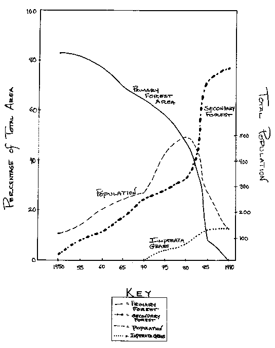
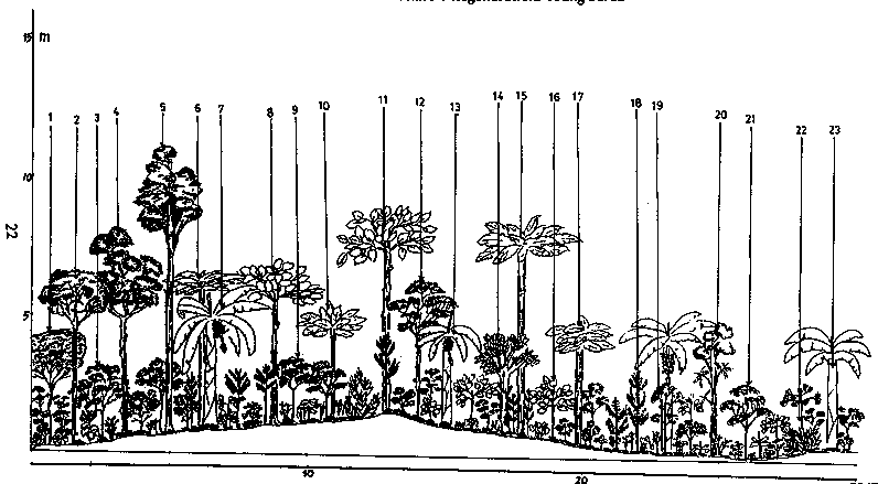
FN 11). In such cases, the mortality rate among larger canopy trees is high.In addition to fire, the sequence of logging followed by government and private-sector conversion of secondary forest for settlements, plantations, and mining has radically altered the landscape around Datarban and greatly reduced its forest cover. In the process, the transformation has undermined the tenure security of small farmers and frustrated their attempts to practice sustainable, long-term rotational agriculture, especially those Dayak households who used such farming systems in Damai. A timeline of major events in Senoni indicates that in only twenty years, a surge of human-induced activities has over-taxed the land, leaving behind an environment which can no longer support small communities at even modest subsistence levels of production (see Figure 4). The decline in population in Datarban and the growing abundance of scrub wasteland and Imperata grass are indicative of the negative changes. While the disappearance of primary forest is dramatic, the resurgence of secondary forest is encouraging and represents an important economic resource to local communities which requires careful management (
see Figure 5).Figure 4
|
1950 |
First Kutai settlers open land in Datarban |
|
1968-70 |
Banjir kap logging operations |
|
1969 |
Weyerhauser granted timber concession |
|
1974 |
Government builds road connecting Samarinda and Tenggarong |
|
1970--84 |
Weyerhauser fells timber in Senoni area and builds access roads |
|
1978 |
Benuaq Dayaks move from Damai to Tenggarong area |
|
1982 |
Major East Kalimantan forest fire |
|
1983 |
Dislocated Benuaq Dayaks join Kutai and begin settling in Datarban |
|
1986 |
Coal mining initiated |
|
1987 |
Accelerated expansion of Imperata cylindrica grasses and scrublands |
|
1989- |
Out-migration and settlement abandonment: forty families leave Datarbari to move back to Mahakam River |
|
1990-91 |
Forest fires |
Over the past two decades, many Buginese, Javanese, and Banjarese migrants have been drawn to this frontier region to claim land and experiment with commercial crops. The experiences of Buginese farmers who establish pepper plantations along the Balikpapan-Samarinda highway is well documented (
FN 12). Research has found that these farmers emphasize quick profitability over sustainability. Erosion rates are reportedly high in pepper-growing areas, with annual soil losses ranging from 52 to 139 tons per hectare. Pepper farmers abandon their fields once productivity falls below a certain profit level and move on to clear new forest lands (FN 13).Under many migrant farming systems, the nutrient-poor peat soils of the region cannot sustain high levels of productivity. Without adequate fallow periods for the recovery of soil fertility and ground cover, nutrient depletion and soil erosion often follow. When the plots are finally left to fallow after extended periods of cultivation, they frequently lack the root stock, seed material, or fertility to promote rapid secondary forest succession. Instead, hardy, invasive plants like Imperata cylindrica dominate, slowing the process of natural regeneration. Frequently, migrants will abandon the area after 3-5 years. The research team estimates that 10-20 percent of the land in Datarban has been colonized by Imperata. This "disclimax" successional state essentially eliminates land from the swidden rotation cycle and places further pressure on remaining lands, threatening them with a similar unproductive fate.
In contrast to the commercially oriented Buginese pepper farmers, who practice monoculture and rely on chemical fertilizer and pesticides until the soil fertility declines, Javanese migrants clear the forest to cultivate rainfed rice, often establishing additional perennial mixed fruit gardens. Unlike many migrant farmers, such as the Buginese, who often have a short-term perspective on land use and extraction, indigenous communities such as the Dayak typically practice more sustainable forms of farming. They employ resource-use systems that minimize soil disturbance and facilitate regeneration under a long-term, rotational cycle. The practices of the Benuaq Dayaks who have settled in Datarban offer important lessons about the renewability of forest resources and the crucial nexus between forest farming and forest conservation.
Informed by extensive ethnobotanical knowledge, Dayaks possess centuries of farming experience within tropical rainforests. Dayak resource-use systems are exceptionally sophisticated in terms of the information and analytic procedures they employ in making management decisions. They are also democratic and consensual in the processes to decide resource allocation and use regulations. The persistence of Kalimantan's indigenous resource-use practices and their apparent compatibility with the region's dominant rainforest ecosystems indicate that, at least in the past, these swiddening, hunting, and gathering activities were both sustainable and productive, comfortably supporting communities with lively social and economic systems while causing minimal environmental problems (
FN 14).In Datarban, however, the Damai Dayaks faced an environment exploited by an increasing number of user groups with different objectives. When Pak Abraham and his fellow Benuaq Dayaks moved to Datarban in 1983, most of the land had been selectively logged but was still covered in closed canopy secondary forest. Dayak settlers planned to use the same long-term rotational swidden farming techniques which they had practiced for centuries in Damai. Pak Abraham explains that, depending on site conditions, sustainable forest farming practices require a fallow period of 8-15 years after a single harvest of dry rice. While the timber concession had selectively felled 1-2 large meranti (Shorea spp.) trees per hectare, most of the area still had dense, regenerating secondary forest. The Dayaks felt that because some of the giant trees had already been removed, it would be easier to clear the forest for their ladangs.
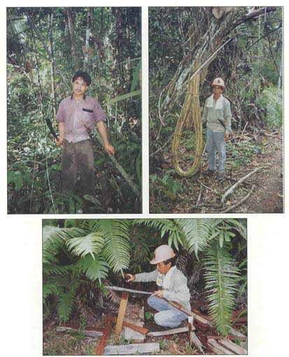
From top: Slashed and burn swidden rice plot has potential to regenerate of land is fallowed after cultivation and protected against further disturbances; natural regeneration of dipterocarp seedlings in the forest understory; a swidden rice field years ago, this young, secondary forest in Datarban has reached phase 3 of the Dayak-classified phases of succession
Pak Abraham and his clan members draw upon a number of time-tested indicators to assess the ecological suitability of sites for opening new ladangs. One indicator of adequate soil fertility and moisture levels involves stabbing the blade of the Dayak machete (parang) to a depth of 30 centimeters. Soil deposits on the blade indicate whether conditions are favorable for cultivating a ladang. Another suitability test requires cutting a 1.5-meter length from the stem of the wild ginger (Hedycium coronarium) and burying it under the humus of the forest floor. If the stem produces shoots within 3-5 days, the moisture and nutrient microclimate is conducive to cultivation. Soils with a dark color are also reported to indicate the presence of higher levels of humus and organic material.
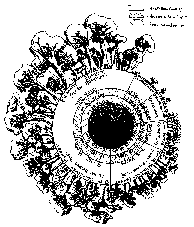
Clockwise from upper left
: Serving as forest guide and key informant to Network researchers, this young Dayak man has developed extensive knowledge about local forest flora and fauna, including species uses, regeneration patterns, and sustainability indicators, Datarban village headman Pak Daniel collects and harvests rattan, a valuable, renewable, non-timber forest product; processing of commercial ironwood shingles from the local Kayu ulin tree is a cottage industry in Datarban.Areas with tall, large-diameter trees, especially from the Dipterocarpaceae family, signify a long history of leaf litter fall with deep topsoil accumulation and the presence of important trace minerals. Particularly desirable indicator trees include Dryobalanops aromatics (kapur), Shorea spp. (meranti), and Eusideroxylon zwageri (kayu ulin). A forest floor dominated by herbs and wild ginger plants from the Marantaceae, Musaceae, Arecaceae, Myrtaceae, and Zingiberaceae families also suggests high levels of fertility.
Other considerations in plot selection include proximity to the community, a river or water source, and a road. The community generally reviews information regarding candidate sites for new fields before making a consensual decision. Household members and elders discuss the advantages and disadvantages of each proposed site, including ecological suitability, potential productivity, logistical convenience, and potential conflicts among families and other groups. In Datarban recently this system has broken down as many Dayak families have left the area and there are no longer enough people to organize labor-sharing for clearing fields. Once a ladang site has been selected, it is usually cleared by a group of men from the village using parangs. Urge trees are typically left behind, especially valuable kapur, putih (honey tree), and meranti species. Slash is gathered into piles and burned to minimize soil damage. Stumps are left to eliminate the need for labor to extract them and to facilitate coppice regeneration. Dayak farmers utilize the swidden plot for only a single crop of rainfed rice, followed by a mixed crop of corn, chilis, and cucumbers. After one rainy and one dry season crop cycle, the plot is left to fallow, although sometimes bananas or a few other fruit trees may be planted to mark ownership.
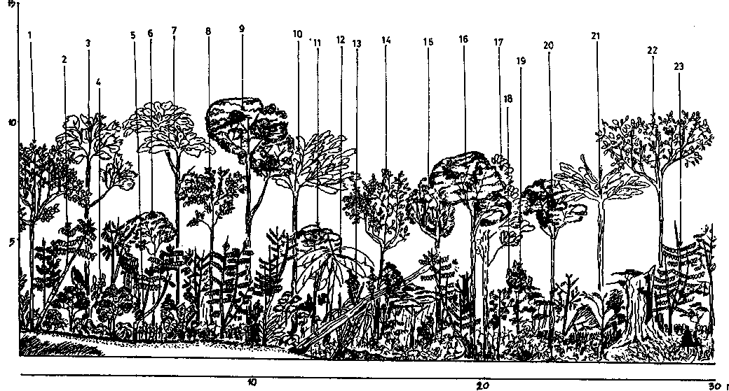
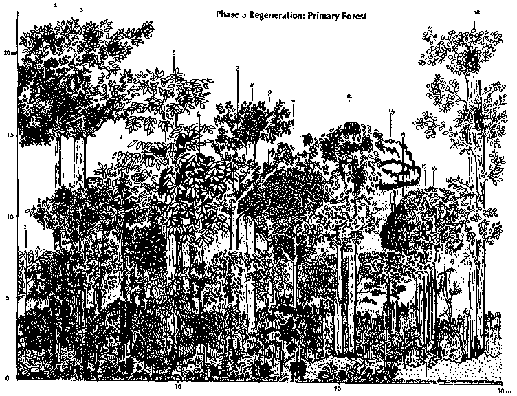
The time required for a forest to regenerate depends on soil fertility and microclimatic conditions in the area, as well as the effects and extent of disturbances experienced earlier during the cropping period and the recovery. The successive phases of regeneration from swidden field to primary forest, as defined by Benuaq Dayaks of Datarban, may take from one to two hundred years (see Figure 6). Regrowth is influenced by such factors as soil conditions, moisture levels, rainfall, temperature, slope, and aspect. Where soils are poor due to leaching, erosion, compaction, or other problems, each phase of regeneration requires a longer period. Benuaq people divide forest regeneration into five phases: young scrub, old scrub, young secondary forest, old secondary forest, and primary forest. The appearance of dense young scrub growth (kurat uraq) usually occurs during the first 1-3 years after field abandonment, depending primarily on soil quality. Light-demanding grasses, perennial shrubs, herbs, and pioneering tree species dominate during this phase, generally reaching heights of 3-4 meters, while canopy closure is usually under 20 percent. Second-phase old scrub conditions (kurat tuha) occur 2-5 years after fields are fallowed. Emergent sapling trees average 5 centimeters in diameter at breast height. Lianas, dense shrubs, and herb undergrowth are common, attaining heights of 5-6 meters.
Figure 6
Bunuaq Dayak Phases of Forest Regeneration
In the third phase of regeneration, young secondary forest (kurat batang muda) succeeds into medium-size pioneering tree saplings of 10-15 centimeters in diameter. This process normally occurs 3-10 years after fallowing, but where soil conditions are poor -- due to fires, exceptional erosion, or otherwise depauperate nutrient status -- the third phase may not be reached for 15 years. As the upper canopy closes to over 50 percent cover, reducing the light below, the grass and herb layers thin out.
The fourth successional phase, old secondary forest (kurat batang tuha), is characterized by significant canopy closure (over 80 percent) and a higher proportion of larger trees over 10 centimeters in diameter. Under good to moderate soil conditions, abandoned swidden plots will begin to generate old secondary growth after 9-15 years and will continue to be classified as such for one hundred years or more until the forest may once again be considered primary (hutan bengkar) (see Figures 7 and 8). Dayaks consider the old swidden plot to have reached the fourth stage when the more valuable hardwood species (meranti, kayu ulin, putih, and kapur) begin displacing the fast-growing pioneering species. The Benuaq Dayaks prefer to wait until the swidden plots reach this fourth successional phase before they open them again. In Damai, Pak Abraham reports that Dayaks prefer to return to previous swidden sites in regenerated secondary forest rather than opening primary forest for their ladangs.
The above classification system reflects the Benuaq Dayak understanding of forest succession and how the ecosystem can still be utilized and manipulated sustainably to maximize agricultural and forest products. As forest succession proceeds, the forest is perceived to gain broader species diversity, higher levels of forest litter, greater canopy closure, increasing humidity, higher rates of nutrient cycling and decomposition, lower soil erosion rates, and generally larger flows of non-timber forest products. These positive changes, combined with recovery of soil fertility and moisture levels, make forest regeneration a highly promoted and valued process among Dayak people.
Figure 7
|
1. Vernonia arborea |
12. Melastoma malabathricum |
|
1. Pterospermum niveum |
13. Sacharrum oficinarum |
|
1. Melannorhoea walichii |
11. Calamus nematospadix |
|
1. Melannorhoea walichii |
13. Melannorhoea walichii |
|
1. Mangifera sp. |
10. Sterculia sp. |
Figure 8
|
Vegetative Composition (30m. x30m. plots) |
||||||||
|
Regeneration phase |
Dayak Classification of Regeneration |
Average Light Intensity (>=1m above ground) (percent) |
Vegeta-tive Cover (>=1m) (percent) |
Grass (Include Imperata) |
Seedlings (<1meter height) |
Saplings (<1.5meter height; <5cm.DBH) |
Poles |
Trees |
|
1 |
Young scrub |
>80% |
20% |
3.4% |
2.5% |
11.7% |
2.2% |
0.2% |
|
2 |
Old scrub |
70 |
30 |
2.4 |
5.5 |
15 |
5.9 |
1.2 |
|
3 |
Young secondary forest |
45 |
55 |
0.0 |
17.6 |
20.9 |
10.5 |
6.1 |
|
4. |
Old secondary forest |
20 |
80 |
0.0 |
21.6 |
20.8 |
17.6 |
20 |
|
5 |
Primary forest |
<10 |
90 |
0.0 |
27 |
14.4 |
18 |
30.6 |
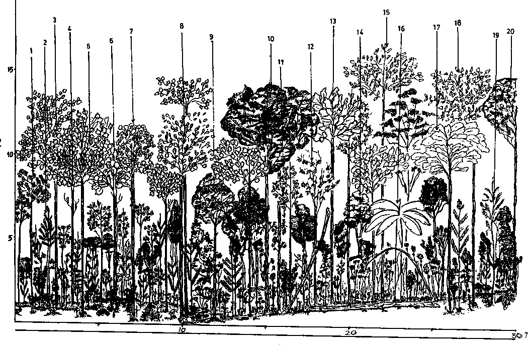
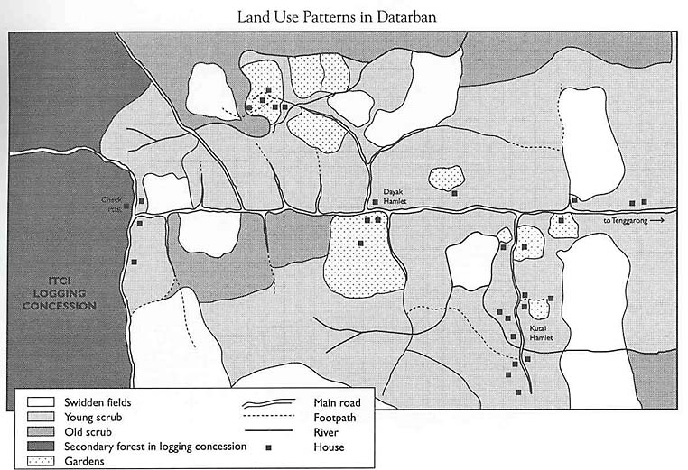
In Datarban, due to the growing land-use pressures and competition from non-Dayak migrants, the amount of secondary forest is no longer sufficient to practice long-term rotation. It is apparent that much of the land near Datarban is under young or old scrub (phases 1 and 2), while a large part of the secondary forest (phases 3 and 4) lies within the ITCI logging concession and is not officially available for use (see Figure 9). Shrinkage of the land estate for rotational swidden has forced many farmers to shorten their rotation, opening phase 2 land which has not yet regained its fertility. Land of this type is particularly susceptible to invasion by Imperata grass and other pioneering weeds. Frequent fires in fallowed swiddens also slow or arrest secondary forest regeneration by suppressing the development of the multi-tiered structure and encouraging weed and grass establishment.
Figure 9
Compromise of the traditional Dayak fallow system is evident in Pak Abraham's personal site selection. He opened his first forest field around Datarban in 1983. Between 1983 and 1988, Pak Abraham continued to open between 1.5 and 5 hectares of land for swidden plots each year. After one year of farming, he abandoned the plots to allow regeneration. In 1989, he was forced to reopen his 1983 ladang since no other secondary forest was available. He notes that his 1983 plot had only begun to enter phase 3 regeneration and should have been allowed to fallow longer. By contrast, Pak Abraham explains that in his home in Damai he would always wait until phase 4. Even so, he feels it might have been feasible to open the swidden during phase 3 had the recurrent fires in the area not disturbed and suppressed the regeneration process.
The introduction of the chainsaw, particularly since 1982, has accelerated the clearing of ladangs. Pak Abraham estimates that 15 percent of the farmers hire chainsaw labor, paying Rp. 60,000 ($30) per hectare. Generally, ladangs are opened in logged-over areas on the old Weyerhauser concession (now PT. ITCI). While signs are posted at the concession entrance that illegal cutting is punishable by 10-20 years imprisonment or fines of Rp. 5-10 million, no one has been accused or brought to court. PT. ITCI has attempted to negotiate an agreement with the local government and community leaders allowing swidden farming in certain areas demarcated by logging roads. It appears that the timber concession's main struggle has been against 'encroachment' by the large coal companies, agricultural estates, and resettlement projects. While the central and provincial governments, as well as a number of technical line agencies, attempt to coordinate planning, conflicts of interest are common. As a consequence, the immense P.T. ITCI concession has gradually been reduced as the government has exerted pressure to release areas for other large-scale interests.
In most cases, the rights of small cultivators are ignored when new allocations of land are made. Pak Abraham experienced this when he opened his first swidden in 1978 in Timbau, approximately 15 kilometers from Datarban. Despite the fact that he had received approval to open his swidden from the local government officer (rukun tetangga -- RT), when a wealthy entrepreneur named Pak Hassan was granted a 15,000 hectare estate that encompassed Pak Abraham's fields, he was forced to move. He appealed to the district government for compensation, but after several years of court inaction, he has received no decision.
Pak Abraham expresses pessimism about the sustainability of his agricultural system: "I have a coal mine on one side and a transmigration settlement on the other. We are being squeezed." In his ancestral homeland of Damai, Pak Abraham describes certain areas of forest that were specially demarcated for protection (lati), only to be used for hunting and the collection of non-timber forest products like honey, birds' nests, and rattan. He would like to see similar protection of forests and a management system in Datarban that ensures sustainable use, but neither the Kutai nor the Dayak residents of Datarban feel they have the authority to organize such a system. Despite his status in the Dayak community in Datarban, Pak Abraham claims he holds no political influence in local government planning or decision-making. Hence, any initiative must come from the local government. Moreover, Pak Abraham predicts that with large coal-mining initiatives, huge rubber and cocoa estates, and government-sponsored resettlement projects, the chances are poor that any local community action to control land use would be effective. However, in Damai, he and the village elders are formulating a proposal to strengthen community claims to ancestral forest lands. They hope that the provincial government will recognize their traditional (adat) rights. They also wish to be vested with the authority to oversee land use and ensure that uncontrolled exploitation like that in Datarban does not occur in their homeland.
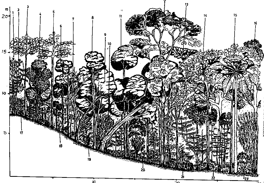
Until thirty years ago, the primary forests around Datarban were used almost exclusively for hunting and gathering of non-timber forest products. For over one thousand years, a significant Southeast Asian trading system supported the exchange of such forest products as rattan, honey, aromatic woods (gahru), birds' nests, gold, resins (damar), and ironwood for shingles (kayu ulin). Collection of forest products in the Datarban area was largely done by Kutai and Benuaq Dayaks living along the Mahakam River near Tenggarong. They would paddle small canoes (ketinting) up the Jahab River tributary, travel into the forest on foot, and carry out ironwood shingles, rattan, and other products.
Over the past few decades, as the forest was first logged for commercial timber and subsequently used for agriculture and mining, the availability of natural forest habitat and associated products declined. Many collection areas were overexploited between 1965 and 1985 and are no longer yielding products (see Figure 10). Collectors still operate, although the remaining secondary and small patches of primary forest are considerably diminished, especially in the Senoni Camp area. However, the ITCI concession has generally followed felling prohibitions on trees which have high value for local communities, including the iron- wood, the kapur, and the honey tree. Products from these trees are still available in some areas.
Figure 10
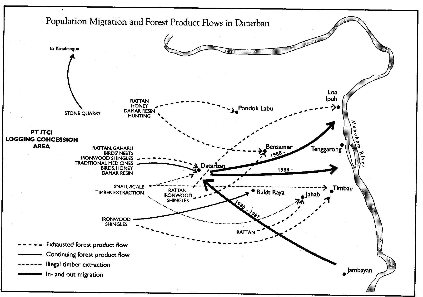
Rattan has been widely exploited in the Datarban environs for generations, although the destruction of the forest environment and overharvesting have greatly reduced its stock in recent decades. Ideal for weaving strong, high-quality mats, the small diameter wei sega is considered the most valuable variety. Good sega is now scarce and currently sells for Rp. 500 per kilogram. This contrasts with lower-grade varieties such as wei biyuang, which brings only Rp. 50 per kilogram. Biyuang is still common, and a collector might be able to gather three forty-kilogram bundles per day. Although collection is difficult, the income is attractive to people with few other profitable activities.
Fine quality rattan sleeping mats, a specialty of many Dayak communities, are woven in 1.5-meter lengths which sell for Rp. 25,000 ($12.50) per 20-centimeter width. Consequently, a 1.5 by 1 meter mat to sleep one or two persons currently costs Rp. 125,000 ($62.50). Such a mat may take two months to weave. While income from mat-weaving averages only Rp. 2,500 ($1.25) per day, the activity is flexible and can be done when convenient.
Pak Daniel, a resident Benuaq Dayak of Datarban, has become increasingly engaged in searching for gahru in the remaining forest near the village. Gahru, (Aquilaria sp.), a fragrant wood product, is found in trees which are infected with a fungus which causes the wood to assume desirable properties. Gahru is used as an ingredient in Chinese incense and in traditional Chinese and Thai medicine. In part because of its rarity, it is very valuable, costing up to Rp. 1.2 million per kilogram (and Rp. 50,000 per kilogram minimum).
Pak Daniel's search for gahru over the past year identified only one tree infected with the fungus. In the process of his exploration, he felled twenty trees. Once a gahru tree is cut, the collector must make several slashes through the trunk to expose the inner wood and determine whether gahru is present. Darker, almost black discoloration and a strong perfume are indications. Exploitation must be done carefully to separate the gahru from surrounding wood fibers. In the one tree that Pak Daniel discovered gahru, he removed approximately four kilograms of mixed qualities, which he sold for Rp. 1 million ($500) to a Chinese shopkeeper in Samarinda.
Many Benuaq Dayak boys and men in Datarban are still actively involved in hunting wild game. The three main hunting systems include spears (tumbak) and dogs to track wild boars; spring traps to catch deer, porcupine, and jungle fowl; and blow guns to kill monkeys and birds in the forest canopy. Hunters may venture into the forest for a month or more, bringing only rice, salt, and oil and surviving off forest foods. Hunting families catch up to eight wild pigs a year, each weighing 30-40 kilograms. Wild boar are typically hunted from January through March, the season when trees are fruiting and the feeding pigs are easier to locate. In addition, those who regularly set and monitor spring traps may bring in 1-2 jungle fowl a week, as well as several species of dwarf (kancil) or larger deer each month. While many important fauna used as local foods still remained after the initial round of cutting in the ITCI concession, subsequent forest clearing for mining, settlements, plantations, and swidden fields has further reduced forest habitat and wild animal populations, making hunting a less productive livelihood strategy. Many village families have experienced a decline in the dietary protein which they used to derive from forest animals.
Another economically important food product gathered in the forest is honey. Certain trees, such as the kayu putih, are specially managed to encourage bees to establish hives. Surrounding trees are often cleared away to permit more light to fall on the tree. Branches are either cut, pruned, or encouraged to grow if they provide favorable hive-building environments. Finally, the trees are protected from cutting by strict rules, fines, and superstitions. Honey tree harvesting rights are often controlled by individual families. The honey is gathered from the hives each year. A productive tree with 25-50 hives can yield up to 300 liters of honey per harvest.
The putih trees are generally left by loggers due to their extremely hard and unforgiving wood. It is reported that the wood has silicates that cause chainsaw blades to spark and become dull. Dayak communities also forbid the felling of putih trees when ladangs are opened. Dayaks believe that some putih trees are inhabited by one-eyed ghosts (hantu). If these ghosts peer at the harvester while he is climbing the tree, he may lose control of his legs and fall. If this occurs, an elaborate ritual must be conducted. These beliefs ensure that care is taken in tending and harvesting honey, while also serving to ensure that use rights, stewardship, and conservation mechanisms are respected.
Ironwood shingles (sirap) are an important source of cash, especially for the Kutai, who typically specialize in this work. They are made from the trunk of the kayu ulin tree. The shingles are highly valued in local markets for their ability to resist termites and rot; villagers report that the shingles can last for several generations. Often when old houses are torn down, the ironwood shingles are carefully removed and recycled. Once an ironwood tree is identified, it is cut with a handsaw or machete. After felling, the worker makes sample cuts to determine if the wood grain is sufficiently straight for splitting into shingles. If not, the tree is left to rot. Once a tree is prepared for splitting, a man can split up to two bundles of shingles per day with his machete, receiving approximately Rp. 3,000 ($1.50) per bundle.
Dayaks also collect many varieties of edible bamboo and rattan shoots. They generally collect 300-500 grams on a trip and might make several trips a week to supplement their diet. While hunting, Dayak men will also collect wild tubers, which are cooked and eaten as a starch. However, as the forest recedes, hunting and food-gathering in Datarban's forests are declining. The forests, soils, water, flora, and fauna have become increasingly depleted, while alternative resources for local community survival have not replaced them.
In summary, forest products play a crucial role in generating cash income and subsistence materials for community residents of Datarban. A survey of household income for 1991-92, however, found that forest dependencies vary substantially by ethnic group. Dayak families receive more of their total income in cash and kind from the forest (29 percent) than from any other source. Hunting, rattan, and gahru comprise most of the Dayaks' forest-based income. Kutai families average 14 percent of their household revenues from the forest, primarily from ironwood shingle manufacturing. Income from swidden agriculture is the dominant source of cash and subsistence for the Kutai (54 percent). In contrast, Banjarese, Buginese, and Javanese migrant families have little dependence on the forest for timber and non-timber forest products and rely more upon sedentary fruit garden agriculture (see Figure 11). As a group, migrants appear least affected by the disappearance of forest products and resources, except for depletion of soil fertility. All groups were dependent on fertile soils for approximately 80 percent of their incomes. The recurrence of the forest ecosystem, through regeneration, is the primary force sustaining soil fertility. As farmers of forest soils, all local residents, including the Dayak, Kutai, Buginese, Javanese, and Banjarese, have a potential long-term interest in maintaining the field-fallow-forest successional cycle.
In the 1970s, much of Datarban was selectively logged. During the 1980s, a series of fires swept through much of the area. Migrants from South Sulawesi, South Kalimantan, and Java moved in to open logged-over forest for cultivation of commercial and subsistence crops. Migrant groups such as the Buginese often had little prior knowledge of agroecological methods to sustain soil fertility in the Datarban environment. Only the Dayaks appear to possess a sophisticated understanding of methods to farm the forest sustainably.
Figure 11
(Percent)
|
|
Source |
||||
|
Swidden Field |
Fruit Garden |
Home Garden |
Forest |
Off-Farm |
|
|
Dayak |
26% |
18% |
6% |
29% |
21% |
|
Kutai |
54 |
14 |
1 |
14 |
17 |
|
Buginese, Javanese, and Banjarese migrants |
48 |
30 |
3 |
1 |
18 |
After much of the forest area had undergone a first round of logging in the 1980s, the central and provincial governments began transferring lease rights from the logging concessions to mining companies and large plantation operators, who had also arrived to clear the forest. The state, which claims control, and the corporations, which are empowered with rights over land resources, have not had sufficient field level capacity to monitor or arbitrate access, further facilitating unsustainable use practices. Competing groups have rapidly reduced the remaining secondary forest, often leaving behind scrub and Imperata grass lands. The declines in vegetative cover have led to soil erosion and lost fertility. Many small farmers are now migrating out of the area in search of new forest land which can be cleared for agriculture. Given the experience of the past three decades, what is the future of Datarban?
In light of past overexploitation and the sandy, nutrient-poor soils of Datarban, agricultural land use will require careful husbanding and management of soil fertility and water supply. Effective resource management must provide tenure security and incentives which encourage long fallows and maximize use of traditional knowledge regarding resource management in a fragile and sensitive environment. The continuation of uncontrolled access and poor management, either by large commercial operations or small migrant farmers, will only result in further resource degradation. This will likely stimulate continued out-migration. In certain tracts which are well managed, smallholder mixed fruit gardens, understory forest and agroforestry plantations, and long-term rotational agriculture seem to offer long-term prospects for productive use. However, the widespread incidence of illegal logging, exploitative farming practices, and unmonitored coal mining are driving the process of resource depletion.
For the future, effective access controls and carefully planned resource-use and conservation strategies need to be tailored to specific local areas. Settled communities, if organized, can provide the most stable basis for developing and implementing these plans. With their superior knowledge of the forest environment and how to use it productively and sustainably, Dayak communities can play a key role in developing protection and management systems which minimize the damage caused by periodic forest fires and enhance the ability of nature to regenerate itself.
Although the rate of forest depletion and environmental degradation has been rapid in the Datarban area, it is hoped that these trends can be reversed. Dayak elders like Pak Abraham discuss how degraded forests might be demarcated and protected, conserving hunting ranges and selected areas for forest product collection. Much of the felled and disturbed forest still harbors considerable regenerative potential if protected from further decline. The regeneration process requires consistent protection, a service which communities can provide if so empowered. However, their needs for tenure security and a share of benefits must be addressed to ensure their commitment. Recent experiences with community-managed logged-over concessions from West Kalimantan are beginning to offer examples of such new management models (
FN 15).