As the degradation of Asia's natural forests continues, and the existence of the region's forest dwellers becomes ever more threatened, the need to halt the procession of social and ecological loss assumes greater urgency. A primary goal of the Policy Dialogue on Natural Regeneration and Community Management was to identify strategic actions to accelerate the empowerment of rural villages as keepers of Asia's endangered forests. Each participating country group, comprising senior government planners, foresters, social scientists, and NGO leaders, was given an opportunity to outline tangible actions that could hasten the devolution of public forest management rights and responsibilities to communities as widely as possible in their specific country contexts. Despite the limited time available, each country successfully formulated a preliminary action plan. Common themes that emerged included the following:
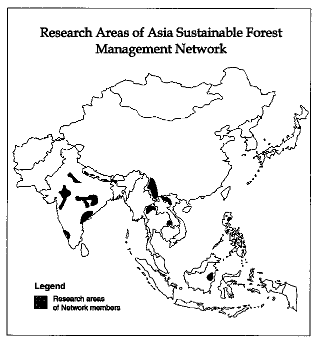
Each country team proposed representative research areas based on their presumed potential for success in community management and its wider replication (see Figure 4). In the future, a more comprehensive inventory is planned to identify high-potential areas for natural regeneration and community management based on selected ecological and social indicators. Ecological factors might include such criteria as available coppice rootstock, proximity to remnant forest patches for seed dispersal, vulnerability to fire, or specific keystone species indicating site fertility status. Important sociopolitical considerations might cover high community forest dependencies, community homogeneity and unity, strong leadership and commitment to equity, environmental concerns and perceived resource scarcities, the presence of indigenous systems of forest, pasture, or water resource management, active government support, or strong religious affiliations with the forest. By mapping both sets of indicators, their areas of overlap can be targeted as high-potential sites on which to initially focus attention.
Figure 4
Country Team: Ben Malayang, Marvic Leonen, Romeo Acosta, Gilbert Braganza, Delfin Ganapin, Ernesto Wijangco, Pat Dugan, Peter Walpole, Delbert McCluskey
Over the past decade, the Philippines has developed a number of policies and programs to decentralize forest management. Many rural communities are demanding greater rights and authority to manage natural forest lands, often attempting to build on traditional use systems. Frequently, the well-intentioned policies and programs of government do not correspond to the needs and conditions prevailing at the community level. Regional (RED), provincial (PENRO), and community (CENRO) officials of the Department of Environment and Natural Resources (DENR) are unsure how to match different community forest management policies with local situations. In response to these needs, the country team proposes to form a working group to better identify sociopolitical contexts in the Philippines in which the Community Forest Program (CFP) of the DENR can be made more flexible and more permanently responsive to local community forest management activities relating to regeneration.
Given the vast upland areas in the Philippines experiencing rapid forest degradation, it is important to accelerate the establishment of effective community-based management controls. Through local protection, the productivity and biodiversity of upland forest ecosystems may be regenerated and sustained. Control of cutting, grazing, and fire will facilitate the processes of secondary succession through natural regeneration. Opportunities for community protection and management vary widely within the country. While community forest management appears to have promising potential in many upland areas, some cultural groups are more cohesive and better organized to take over responsibilities than others.
The country team concluded that it is necessary to identify the existing human-forest contexts within the Philippines to understand how to respond strategically to varying needs and conditions. The Philippine Working Group will begin meeting on a regular basis, to allow a small group of senior policy makers, NGO leaders, and researchers to systematically monitor a variety of upland sites. The group hopes to identify the types of areas where community forest management systems could be established quickly through local leaders and organizations if provided encouragement.
Where communities are already involved or interested in forest management, management authority can be rapidly devolved, while maintaining technical support in mapping ancestral domains and certifying agreements between the DENR and communities. Where local organizations are still vital, an orderly establishment of partnerships between upland communities and the DENR could spread quickly from sub-watershed to sub-watershed. In other areas, where the social-political environment is more complex or where no leaders or organizations are present to facilitate the emergence of a coalition and consensus for resource management action, the process may be more time-consuming and require different policy and program mechanisms. Increasingly, communities in the uplands are pressing ancestral domain claims, and the procedures are being more widely tested.
The country team selected ten sites for diagnostic study and monitoring in various parts of the country, to improve understanding of the types of field-level contexts and different approaches necessary for community management. The proposed working group will examine the progress and prospects for accelerating community forest management initiatives in five areas where government CFP projects are under way, and five sites where upland villages are involved in non-governmental research or action projects.
High-Potential Areas: The ten sites selected were considered to possess high potential for rapid establishment of community forest management or ancestral domain agreements, because they have strong traditional organizations and management of non-timber forest products, good local leaders, and/or positive government support (see Figure 5). The first group of sites are populated by indigenous tribal communities with strong traditional leadership and institutions. Tinoc (Banaue-Mayoyao), located in Northern Luzon and inhabited by Ifugao people, is an area believed to possess strong traditional management systems. Ancestral-domain mapping programs may be appropriate strategies to decentralize and empower local groups as forest managers. Sangilen in Mindoro Oriental was chosen to represent traditional Mangyan communities with strong leadership and local organizations. Successful establishment of ancestral domain agreements with the DENR in Sangilen could feasibly spread to the thirty-two other Mangyan communities in Central Mindoro, allowing all of the island's upland watershed to come under community forest management systems.
Figure 5
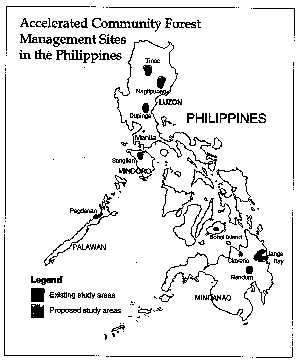
The second group of sites will be used to explore how commercial logging areas might be transferred to communities for management. In Lianga Bay, located in eastern Mindanao, the DENR is exploring a Community Development of Residual Forests (CDRF) agreement with local groups and church leaders. This area provides an opportunity to explore how the transfer of commercial logging concessions to community management groups might be achieved. Pagdanan, on the island Palawan, was also felt to be a good location to develop CDRF agreements, due to the strong interest of local government.
The third program area will explore ways to stabilize forest management where large migrant communities are moving into upland watersheds with small tribal populations. In the Sierra Madre mountains of eastern Luzon, program sites were chosen in Dupinga and Nagtipunan. In Dupinga the Dumagat, Tagalog, and Ilocano communities have organized (with the help of NGOs) to halt logging in this important watershed. In Nagtipunan, the entire province has been identified for extensive community forest management programming. Both areas are challenging, as the indigenous people are a small minority with a diverse migrant population; it is less clear what CFP agreements might be most suited to local conditions. Claveria and Bendum sites are both located in the central mountains of Mindanao. In both areas, NGOs have assisted tribal communities to organize. In Bendum, several Bukidnon communities are positioned to manage parts of this critical upland watershed under an ancestral domain agreement. They are not, however, a unified political group and are under pressure from Visayan peoples who have migrated into the area.
Program Strategy: In the first phase the working group will combine regular meetings with site visits. The site visits are intended as a venue for discussion among the members regarding high-potential site characteristics, the strengths and weaknesses of current policies and programs, and tools for accelerating community management projects. The findings will be presented at the Asia Sustainable Forest Management Network meetings in October 1994. During these visits other researchers will be invited to contribute to the working group's discussions. The three-day visits are intended as occasions for intensive field observation and community interaction. Each visit will be followed by a working group meeting to synthesize each member's analysis of the field conditions.
An attempt will be made to establish and support community-based documentation, implementation, and monitoring in the sites described above. Priority research activities will be identified to assess the appropriateness of current policies and programs and the broader public response to forest management activities. The working group will attempt to identify strategies to make the CFP more responsive to local situations and needs, and to accelerate the adoption of DENR programs. Social and ecological criteria to identify high-priority areas for CFP will be developed. The result of this research will be shared with other government agencies and the NGO community by the end of 1994.
In Phase Two, the working group will begin consultation with other government agencies and NGOs to begin developing national baseline maps of high-potential areas, utilizing social and ecological criteria developed in Phase One. This activity would be conducted in 1995. During Phase Three, extending from 1996 to 1999, accelerated programs for community management will be fully implemented in high-potential areas. Community groups will be supported to expand existing forest protection activities, encouraging neighboring communities to join in management efforts throughout larger watershed areas chosen for initial program activities.
Country Team: Oekan Abdoellah, Roedjai Djakaria, Agus Djoko Ismanto, Oktavianus Kamusi, Kuswata Kartawinata, Abubakar Lahjie, Owen Lynch, Sandra Moniaga, Tri Nugroho, Sopari Wangsadidjaya, Chip Barber, and Jerry Bisson
Indonesian planners have been working with donor organizations and NGOs in recent years to design a number of new programs and pilot projects for community forest management. The government is currently formulating a new strategy to stabilize natural forest resources under Permanent Forest Management Units (KPHP). Indigenous forest management systems would need to be integrated within or outside the KPHP. Since KPHP is a new, still-developing concept and program, it provides an opportunity for incorporation of innovative community management strategies. In addition, the Ministry of Forestry is experimenting with community timber concession management (HPH Masyarakat) underway in West Kalimantan with German bilateral support. This project allows local communities to assume some management responsibilities for production forests. The Traditional Forest Area (TFA) is another pilot program that attempts to operate within a timber concession. This approach is being developed under the USAID-supported Natural Resources Management Project in the Bukit Baka/Bukit Raya Park area in West Kalimantan. An Integrated Protected Areas System (IPAS) is also being pioneered by the Forestry Department on Siberut and Flores islands with financing from the Asian Development Bank. Finally, support from the Global Environment Facility (GEF) is financing experiments with community management in Sumatra's Kerinci Seblat National Park and adjacent areas. The Indonesian team noted that it was important to facilitate exchanges of information between these programs to accelerate learning regarding approaches to integrate communities within the formal forest management sector.
High-Potential Areas: The Indonesian country team identified Kalimantan as a high-potential area for establishing new community forest management agreements. In recent decades, Kalimantan has been the center of Indonesia's timber industry and an important destination for migrants from other parts of the country. These events have had a dramatic impact on forest cover across the island. Although some of this area has been targeted for reforestation, millions of hectares are unprotected and continue to be degraded. In some areas traditional communities are well-positioned to take over protection activities.
Within Kalimantan, the central drainage of the Mahakam River, covering approximately one million hectares, is a strategic region for developing community forest management activities (see Figure 6). The area falls between the coastal plain, with its growing urban centers in Balikpapan and Samarinda, and the remote mountains along the Sarawak border. The central Mahakam is a critical upper catchment supporting the Melintang wetlands, which include the largest lakes on the island of Borneo. In the coming decade, it is likely that much of the natural forest in the coastal area will be converted to plantations, agriculture, and human settlements. The central Mahakam would be managed as natural production forests with the participation of indigenous peoples.
Figure 6
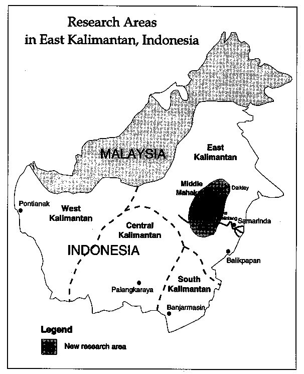
Initially, a feasibility study will be conducted in the area in and around the KPHP to determine which area is most suitable for a diagnostic study to promote community-based forest regeneration and management. In this process, weaknesses in the KPHP framework in relation to community participation and management need to be identified. It was suggested that exploratory diagnostic research be initiated in the Damai area of East Kalimantan, where the Benuaq tribal communities are reportedly developing proposals to formally share forest management responsibilities. There is also an NGO Working Group on KPHP, which could help facilitate discussions between forest communities and the local government. This case study would clarify procedures to reach agreements between local groups and government, while generating methods to adapt emerging KPHP systems to integrate traditional systems of forest management. As a companion activity, a broader survey of traditional forest management groups in the central Mahakam will be initiated.
The survey will attempt to identify communities willing and able to undertake community forest management activities. The survey will also map the existing forest-management domains of tribal and migrant communities. Existing government planning agency (BAPPEDA) maps (produced by Germany's GTZ project), available at a scale of 1:50,000, can be utilized, as can RePPProt's transmigration project maps (1:250,000) and the large-scale land use agreement (TGHK) maps (1:500,000). Mapping of traditional forest use territories can assist with KPHP planning. The longer-term effort will build capacity within provincial forest departments to incorporate community-based natural regeneration studies and activities into the KPHP model throughout Kalimantan.
Program Strategy: To inventory local claims and occupancy of traditional and public forest lands, it is essential that the working group identify existing institutions that can assist with this process. Traditional village institutions, tribal councils, and other informal community bodies, acting under customary law (hak ulayat), can help illuminate forest use practices, identifying areas where territory is undisputed and where conflicts exist. In addition, the working group will inventory local government agencies, churches, NGOs, universities, and informed individuals with potentially important roles to play.
Once baseline feasibility study data are in place and key local institutions and individuals are inventoried, the working group members propose conducting a series of informal forums at village, sub-district, and district levels. Based on the information and agreements generated through these informal gatherings, one or more formal meetings with relevant agencies and officials will be held to obtain local government support for the emerging management plans.
The Institute of Ecology at Padjadjaran University will continue to facilitate the project in cooperation with Mulawarman University as field implementor in East Kalimantan. Both institutions will work in cooperation with the Forestry Department. Local NGOs in East Kalimantan will assist the field researchers in inventorying indigenous communities and in documenting their forest management territories and use systems. As the work in East Kalimantan progresses, a second action research site will be initiated in West Kalimantan with support from local NGOs and universities.
Country Team: Lert Chuntanaparb, Komon Pragtong, Uraivan Tan-Kim-Yong, Wanida Subansenee, Bunnalert Rushatakul, and Sainer Limchoowong
The Royal Forest Department (RFD), in conjunction with university-based researchers and NGOs, has begun a systematic effort to document local forest management systems nationwide. While formal community forest management policies are still under discussion and debate, considerable progress has been made in Thailand to inventory and support the expansion of local initiatives to stabilize forests. This has involved an attempt to link formal forest management systems with informal community-resource protection and use activities.
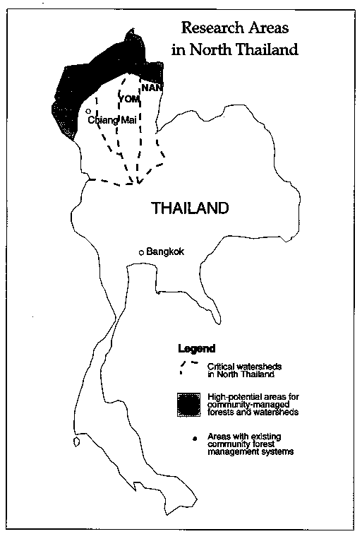
North Thailand is a particularly important region of the country because of its critical watersheds. The Ping, Wang, Yom, and Nan are all strategic upland areas for the central agricultural plains. Between 1967 and 1985, forest cover in the North declined at a rate of almost one percent each year (Pragtong and Thomas 1990). Policies to resettle upland communities of ethnic minorities met with political resistance, and did little to stem the process of forest degradation. Additionally, not many of the donor-funded crop-substitution programs were effective.
The breakthrough described previously was the initiation of the Sam Mun Watershed Project, which brought RFD staff together with community leaders to develop cooperative management agreements for micro-watersheds. While a government-supported project has accelerated the emergence of village-level sub-watershed management forums (which in turn now supervise land use in the Nam Sa catchment and five other sub-watersheds in the larger Sam Mun watershed), monitoring studies by social scientists at Chiang Mai University indicate that many tribal communities are starting to establish watershed management organizations on their own accord throughout the greater Ping Watershed located along the border.
High-Potential Areas: The Thailand Working Group felt that the North's upper watersheds should receive priority for community forest management, due to the rapidly emerging interests of local tribal villages, the important linkage to lowland agriculture, and the significance of international border areas. It appears that major grassroots initiatives are being driven by Karen tribal leaders. The Karen have been settled longer in the upland watersheds of North Thailand and are increasingly practicing terraced, irrigated rice cultivation on mid-slopes. Their agricultural systems are threatened by upland tribal communities who clear ridgetop forests to open swidden fields, often disturbing spring flows and sending heavy sediment loads downstream. At the same time, all hill tribes feel vulnerable to lowland Thai migrants and commercial interests ascending into the hills. For these reasons, the Karen are organizing and attempting to work with other hill tribes to forge resource management agreements. The Thai government's growing openness to community-based resource management has encouraged villagers and NGOs to expand these initiatives. The effectiveness of Karen attempts to stabilize resource use and establish management institutions appears related to the existence of tribal networks, according to Uraivan Tan-Kim-Yong. Over the past five years, Karen leaders based in the Omlong sub-watershed have encouraged other Karen communities in the Mae Chaem, Mae Klang, Pai, Mae Tia, and Mae Ya watersheds to initiate management activities. Once Karen villages become organized, they often begin contacting Hmong and other highland tribal communities to encourage them to cooperate.
Program Strategy: At the current rate of expansion, large areas of the Ping watershed can be enlisted under local management control within the next decade. Some tribal activities in the Wang and northern Yom and Nan watersheds also appear to be emerging (see Figure 7). The Strategic Action Plan includes monitoring the expansion of these efforts throughout the northern watersheds. A spatial inventory will identify and map areas where tribal communities have already established effective use controls or where such systems are beginning. Existing topographic maps, sketch maps, and three-dimensional watershed models will be used to collect this data, which will then be collated on topographic maps and into a GIS database. Where groups are already present, the RFD will attempt to register them formally. An attempt will also be made to anticipate where such groups can establish community-based watershed management systems. In prospective areas, the working group will assist local foresters and NGOs to visit neighboring watersheds already under community management, or to hold educational activities. Special training and orientation programs will be arranged for RFD field staff and NGOs to apprise them of recent grassroots movements oriented to watershed management. In addition to inventorying and mapping activities, diagnostic studies in sampled communities in the North will be periodically conducted to determine the types of strategies being adopted by villages to regulate resource use. Studies of natural forest regeneration in community-protected watersheds will monitor forest succession patterns. Finally, new economic development programs will be developed based on non-timber forest products and ecotourism. The Northern Thailand Social Forestry Working Group, comprising RFD staff., government upland and watershed development project staff, university researchers, and NGO staff, will oversee the program. The working group will continue to meet regularly to accelerate activities.
Figure 7
Country Team: Anil Shah, Ajit Banerjee, Arvind Khare
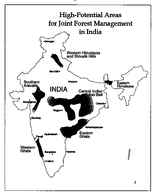
On the policy front, national guidelines and government orders from fifteen states have already been ratified supporting community empowerment for the management of public lands. Joint Forest Management (JFM) initiatives in India are already progressing rapidly in some areas. However, despite recent progress,, only a small proportion (perhaps 1-2 percent) of India's forests have come under effective access controls. A major gap continues to exist between policies, supportive programs, and field realities. Current policy only allows for communities to protect degraded forests. The India country team has concluded that communities should be allowed to protect any threatened forests, regardless of its vegetative conditions or function, whether reserve, protected, or national park.
High-Potential Areas: Generally, joint forest management should be pursued most intensively in areas with high tribal and forest concentrations (see Figure 8). In such regions, already many communities are interested in acquiring formal authority as forest managers. In targeting specific areas for information campaigns by the Forest Department or NGOs, outside facilitators should seek communities with heavy forest dependencies, interest in acquiring forest management responsibilities, and the presence of motivated forestry field staff, NGOs, and local colleges or universities that could assist the expansion of JFM programs. Priority should also be given to forest areas with good ecological potential for rapid regeneration, characterized by high densities of coppice root stock and multiple species with valuable subsistence and marketable products.
Figure 8
Program Strategy: State-level working groups will need to be bolstered where they exist or be developed in high-potential regions to guide the implementation and acceleration of JFM programs. These working groups will be responsible for collecting inventory information on existing community management groups and identifying priority areas that require information and extension programs. Using the ecological and social criteria outlined above, each state will select one or two forest divisions in each district for intensive program activities.
Each division will form a separate working group under the leadership of the divisional forest officer. The working group will comprise range officers, local NGO workers, and other interested parties. The range officers will be responsible for conducting spatial inventories of their territories, indicating all communities protecting forest tracts, and the ecological condition of each forest patch in the range. This information will be recorded on existing topographic maps of the area on a scale of 1:50,000. Based on this finding, the Divisional Working Group will analyze each range, identifying priority communities and forest tracts where JFM might be most effective. The Divisional Working Group will arrange exposure visits to allow leaders from high-potential areas to visit successful JFM communities.
A national Working Group for Joint Forest Management needs to be established within the Ministry of Environment and Forests. With the participation of state-level foresters, NGOs, and researchers, the national working group will monitor and support the expansion of JFM activities within India. Over the next five years, research priorities will examine the relationships between informal community forest management organizations and local governance (panchayat bodies). Studies will also investigate the equity implications of allocating public resources to selected communities in terms of its effects among villages, among social and gender groups, and between the state and the village. Finally, it will be important to analyze the comparative economic productivity of lands under JFM versus state management. Technical studies will help assess how to enhance the productivity of regeneration and extraction methods for non-timber forest products and their processing and marketing.
Country Team: Coordinated by Nguyen Huy Phon, deputy director of the Forest Inventory and Planning Institute (FIPI), Ministry of Forestry, Hanoi
Recently in Vietnam, the prime minister made reference to the crisis of upland forest degradation. The mountain regions on the northern and western borders of the country are critical watersheds for the densely populated agricultural plains below. They also support approximately sixty ethnic minority groups who practice swidden cultivation. Over one-half of the nation's 18 million hectares of forest land has been deforested (Talbott and Morris 1993). Past policies have stressed resettling ethnic minorities and sedentarizing shifting cultivators; however, this often stimulated an influx of lowlanders into "abandoned" uplands. As in many Asian countries, Vietnam's forests have suffered from conflict between local communities and the government, and from a lack of understanding of indigenous land use practices and tenurial arrangements. As a result of the failure of state resource management policies to address local use needs, forest lands have not received the intensive, systematic management required to sustain them in the face of growing population pressures.
High-Potential Areas: The program will focus on Cuc Phuong National Park, south of Hanoi, and the Da River watershed, west of Hanoi. This watershed, bordering China to the north and Laos to the south and west, has experienced extensive forest degradation in recent decades.
Program Strategy: During the first phase of the program, an interdisciplinary diagnostic research team will be formed at FIPI. Participants will include foresters, social scientists, geographers, and botanists. The team will begin by familiarizing themselves with participatory rapid appraisal (PRA) techniques. Initial training activities are to be carried out in Cuc Phuong National Park, one of Vietnam's most important wildlife reserves and inhabited by lowland Vietnamese (Kinj) as well as Muongs. The PRA exercise will attempt to document community-forest interaction patterns and dependencies on forest resources in space and time. The data will serve as a basis for dialogue between park managers and local villagers regarding the establishment of a community-managed buffer area around the park. The findings from this initial round of diagnostic research will be presented to members of the Asia Sustainable Forest Management Network at their annual meeting in October 1994, to be held at the park.
In the second phase of the program, additional research sites will be selected for study in the Da River watershed. A small sub- watershed with at least three different ethnic minorities will be selected for study communities. The research area should reflect a variety of land use systems where degraded forest lands possess good regenerative potential. Ideally, the area will have both traditional resource use strategies and newer initiatives to respond to forest management problems and opportunities.
After conducting an initial round of diagnostic research, the FIPI team will hold a series of meetings with local forest agency staff and government officers to explore ways to formalize sub-watershed partnerships between local communities and government. The team will act as both facilitator and documenter of this process. Case materials from the action research program will be shared and extended to other forest department staff.
Country Team Leaders: Xu Jianchu and Lu Xing
Proposed Participating Institutions: Kunming Institute of Botany; Yunnan Institute of Geography; Southwest Forest College (Kunming); Yunnan Academy of Forestry; Yunnan Academy of Social Science
In Yunnan province, southwest China, large tracts of forest were felled during World War 11. During the Great Leap Forward in the late 1950s, logging expanded to provide impetus for economic growth. Deforestation accelerated again during the Cultural Revolution of the 1960s, leaving little forest in the northern and eastern parts of the province. The province now possesses 10 million hectares of good forest, with another 17 million hectares degraded, much of it located in upland watersheds to the south and west of Kunming. These critical watersheds, which form the headwaters of the Mekong and Red rivers, are primarily inhabited by minority ethnic groups, most of whom live below poverty levels. Deforestation and erosion there threaten not only these upland communities in Yunnan, but also their neighbors in Thailand, Laos, Cambodia, and Vietnam. Sediment flows into the Yangtze are estimated to exceed 1.4 billion tons annually. Community resource management institutions in remote watersheds in Yunnan's mountains appear to persist and could be strengthened to stabilize resource use. China appears to be open to exploring joint forest management agreements with local communities. However, a better understanding of institutional structure, function, and spatial distribution is urgently needed.
High-Potential Areas: The country team felt that priority attention for community forest management in Yunnan province should be given to the mountainous regions northwest, west, and south of Kunming. These areas are populated by a number of minority ethnic groups who have maintained their cultural traditions and are still dependent on forest lands. Hence, they may have the economic incentive, as well as local institutions and leadership, to formally assume responsibilities for micro- and sub-watersheds. This area comprises the headwaters of the Mekong and Salween rivers, which support large downstream farming populations throughout mainland Southeast Asia.
The team plans to initially focus diagnostic studies in the subtropical forests near Simao, located in the Lancang River watersheds. This area, south of Kunming, possesses isolated, relatively undisturbed forests. However, forest pressures have increased in recent years with the initiation of logging operations in the area. During the first round of research, diagnostic methodologies will be used to inventory and map the locations of indigenous communities and their forest lands.
Program Strategy: In recent years, a number of action research programs have documented indigenous land use systems. The Yunnan Institute of Geography is developing a program to map traditional land use practices using geographic information systems. The Kunming Institute of Botany hosts the newly established Participatory Rapid Appraisal (PRA) Network, with members from several Kunming research organizations. The staff are conducting studies of forest and agricultural resource use systems in collaboration with the Southeast Asian University Agroecosystems Network. This research is revealing the presence of complex traditional systems of land use that are both efficient and sustainable. Due to the increasing shift from a subsistence to a market economy and the growing presence of outside entrepreneurs and development projects, these systems are endangered.
Lu Xing of the Yunnan Institute of Geography and Xu jianchu of the Kunming Institute of Botany suggested that a project be initiated to inventory, map, and formally recognize ethnic communities managing forest lands in southern and western Yunnan. A working group will design and monitor the implementation of the project. Diagnostic case studies of each major ethnic group's forest use patterns will be compiled, using methodologies similar to those of other network country teams. Based on the findings from the diagnostic assessments, a series of pilot project sites will be chosen to further field test the guidelines and procedures for formalizing community management agreements. These demonstration areas will also provide a basis for disseminating joint management experiences to neighboring watersheds. The project will be designed and guided by foresters, social scientists, and ecologists in the PRA Network, based in Kunming. The young foresters are former classmates of Lu, a graduate of Kunming's Southwest Forest College. Data collected will include information on customary forest and land boundaries, indigenous management rights and responsibilities, and patterns of forest succession as reflected in indigenous knowledge. The first round of information collection will be used to formulate a typology of systems of indigenous forest management for major ethnic groups in the area.
A time series of aerial photographs and satellite images will also be used to examine changes in forest cover and land use related to government policies and projects. The data will be discussed with forest department staff in provincial - and county-level working groups to examine their implications for changes in management. Particular emphasis will be placed on assessing the feasibility of formally empowering community groups as joint managers of public forest lands.
Once the first round of data has been collected and discussed at the working-group level, a policy workshop will be held in Kunming to disseminate the findings and prepare guidelines for implementing joint management agreements. Periodically, during the course of the program senior researchers, foresters, planners, and community leaders will visit watersheds in North Thailand, where ethnic tribal groups similar to those in Yunnan are rapidly extending community forest management systems.
Country Team: Madhav Ghimire, C.P. Upadhyaya, Ridish K. Pokharel
Nepal, like many other Asian countries, has experienced considerable activity in the community forestry sector over the past decade. Despite many bilateral and multilateral programs, progress in establishing community forest management systems has been slow. With a population approaching twenty million, pressures on fragile hill forests are high. A policy shift over the past few years to empower local user communities, rather than local panchayat governments, has helped to decentralize authority.
High-Potential Areas: Despite the massive investment in community forestry in the middle hills of Nepal in recent decades, the most threatened forests -- those of the Churia Range (Siwalik hills) just above the Terai plains -- have received less attention. Due to their proximity to Terai road networks, the forests of the Churia Range have been rapidly exploited. They are also under pressure from Ml migrants who clear the land for farming. The indigenous tribal communities, including Chepang, Tharus, and Sunawar, are often unable to withstand the political and economic power of the Terai and hill people. New ways to strengthen local communities as forest managers will be important, not only in preserving the Churia forests but also in maintaining their hydrological functions for the primary grain-producing regions in the Terai plains.
Program Strategy: The Nepal team plans to identify a small group of young district forest officers working in the Churia area who are interested in experimenting with new techniques for mapping local forest tracts and user communities. Through this activity, they will develop procedures for locating vulnerable forest areas and communities that could protect forests under pressure. The objective is to design strategic spatial and social planning tools for territorial forest administrators that facilitate community participation activities.
Donor Group: Pamela Muick, Eva Wollenberg, Alex Moad, Kathryn Saterson, Linda Lind, Stephen Kelleher, Malcolm Jansen, and Jeff Sayer
Donors are also faced with formidable challenges as they attempt to support strategies to stabilize Asia's forests. Most agree that past capital investments in plantations and technologies have had little positive impact on ensuring the survival of natural forest ecosystems. Donor agencies operating in the postwar era have assumed that their primary role is capital and technology transfer. The role of bilateral and multilateral donors assisting forest departments and rural villages in decentralizing management is far less clear. There is an immense need for research, training, inventorying, surveying, and mapping. Still, many of the operational strategies for conducting these activities are still in an early phase of development.
Pam Muick from USAID's Asia Bureau for the Environment, reporting for the donor group, noted that although bilateral agencies are experimenting with small grants programs, these strategies are often time-consuming due to the excessive paperwork required. Bilateral agencies are also responsible to their governments to ensure the proper use of development funds and consequently must provide extensive documentation and monitoring. These requirements constrain such agencies' ability to respond rapidly to requests for flexible funds. USAID is experimenting with the provision of large grants to umbrella NGOs to expedite the flow of funds to smaller NGOs. Examples include the Biodiversity Conservation Network, administered through the World Wildlife Fund, and a recent grant to the Foundation for the Philippine's Environment.
The donor group also noted the need for better coordination among funders. They suggested the possibility of forming a donor group on community forestry. Currently, a series of working groups, roundtables, and seminars are periodically held in Washington, D.C. The Consultative Group on Biodiversity and the Environmental Grant Makers Association are examples; however, both are under-represented by donors outside the United States and need to expand their membership.
The donor group concluded that there was a need for donors to be more consistent in their funding priorities. Abandoning grantees who are still learning to be effective can undermine capacity building. The development of strategic plans by donors that are shared with grantees and NGOs would be a helpful mechanism in facilitating coordination between donors and implementing groups.
The Indonesian country team made several recommendations to donors regarding ways to enhance their effectiveness. These recommendations deserve serious consideration since they are contributed by individuals with extensive direct contact with donor- supported forestry projects.
It was observed during the meeting that while many planners in developing nations may feel it is the role of the North to make much greater financial contributions to the forestry sector, experience indicates that massive financial investments in emerging community forest management initiatives may be counterproductive. A recent case from India dramatically illustrates this problem. In south Rajasthan, a dedicated divisional forest officer noted that much of his staff's time is devoted to planting a few hundred hectares of highly degraded land using donor funds, while the remaining 170,000 hectares of forest lands under his administration are rapidly degrading due to illegal cutting and overgrazing. The donor support is, in fact, drawing attention away from focusing staff time on resolving the resource conflicts that are driving forest degradation. The hundreds of millions of dollars invested in plantation work do little to resolve the management crisis confronting natural forests, and the huge sums of borrowed money build large national debts that must be repaid in the future.
Perhaps even more subtly undermining, foreign assistance flows primarily to government agencies. This empowers the government, not the forest communities that are the most critical element in stabilizing forests, with resources. While there is little doubt of the sincerity of donor's efforts to contribute to solutions to forest degradation, serious questions arise over their standard modes of operation. Smaller quantities of flexible funding, provided in a phased manner with careful monitoring through cooperative working groups, might help donor agencies learn to work more effectively with government agencies and communities. Better interactions among donor NGOs and bilateral and multilateral agencies would allow each to draw from their strengths and complement each other's work.