Studies of vegetation conditions and patterns of ecological change in natural forests are essential for management decision-making at the state, district, and village levels. Due to the immense ecological and microclimatic diversity found in India, it is necessary to conduct localized studies to understand and respond to the highly varied environmental contexts. Knowledge of the vegetative characteristics of forest ecosystems can be effectively combined with economic and institutional information to develop participatory and locally-adapted management systems based on appropriate resource development strategies. Forest vegetational status and dynamics can be investigated through a combination of conventional ecological mensuration methods and participatory research techniques. The methodologies advocated here differ in certain ways from conventional forest ecosystem studies in terms of approach, time line, and audience. Traditional ecosystem research has been typically directed toward an academic audience and often requires lengthy data collection. In contrast, these methods are designed to generate a rapid understanding of the vegetative conditions in natural forests utilized and/or managed by community groups. The main purpose of study is to help communities generate practical management options that will lead to optimal productivity, while also responding to environmental needs. Resulting management options will be site specific and tailored to local vegetation, economic and institutional factors. Data on vegetation status by itself may not be sufficient to generate viable management options.
The target groups utilizing the vegetation data for generating management options include Forest Departments, NGOs, local institutions and communities. For planning purposes, these groups require timely information that allows them to identify trends reflecting degeneration or regeneration and corresponding productivity levels for important species under current and potential use practices. These groups are not likely to be trained to carry out complex conventional ecological research, and they often do not have the time to wait for lengthy studies. To respond to the requirements of forest managers, whether they be government officers or villagers, vegetative assessment methods should be rapid, simple, user-friendly and applied. The goal is to guide the generation of management options rather than simply describing the forest or grassland ecosystem. These methods also can facilitate community involvement, both capturing the experiences and collective wisdom existing among village members, and bringing families into a dialogue concerning the vegetative state of the forest and how it could best be managed to meet their economic and ecological needs. An exemplary range of participatory vegetative assessment techniques are described in the proceeding section.
A cross section of examples illustrating common management issues and research parameters, sites, and field methods are presented in Figure 18. Typical issues may include the annual amount of fuelwood or tree leaves that can be extracted sustainably, or the impact of forest protection and increasing canopy closure on fodder grass yields.
Figure 18
Ecological Management Issues, Parameters, and Research Methods
|
Management issue |
Vegetation parameters to be investigated |
Site Selection |
Methods for Study |
Calculations |
|
1. Quantity of sustainable harvest of firewood |
- Species of all trees - Size distribution of trees (DBH and height) - Density of tree species - Basal areas - Coppicing nature - Stump or root stock/ha |
- Plots at different distance from settlement up to 2km, 2-5 km. 5-10 km. - Plots with headload removal-vs-cart or truck removal. - Protected and regenerating plots - Control plots: open access, undisturbed |
- Quadrat method |
-Standing biomass -Productivity - Quantity of wood removal for sustainability |
|
2. Sustainable lopping levels of leaf biomass for manure/fodder |
- Species name DBH and height distribution - Vegetation profile - Legume/non- legume trees distribution - Shrub and tree app. density - Coppicing nature - Basal area |
- Plots of different lopping intensity; high, moderate, low - Plots at different distance from settlement (2 km, 2-5 km., etc.) - Category of land: reserve forest, protected forest, private forest - Control plot where no anthropogenic lopping |
- Quadrat method - Sample tree harvest method |
- Shrub and tree leaf biomass - Productivity - Quantity of leaf removal for sustainability |
|
3. Impact of protection on grass productivity |
- Monthly grass yield - Vegetation profile - DBH and height of trees - Canopy cover - Basal area of trees |
- Plots under different periods of protection: 3, 5, 10 years, 10 years - Control plots: free grazing, no grazing - Regulated removal plots |
- Quadrat method - Harvest method |
- Grass productivity (annual) - Tree productivity |
|
4. Sustainable leaf collection level for plate-making |
- Name of all trees used for leaf-making - DBH and height distribution of trees - Basal area of trees subjected to leaf removal |
- Plots under different periods of protection; 3, 5, 1 0 years - Plots at different distance from settlement - Control plots: no removal, open access |
- Quadrat method - Sample tree harvest method |
- Leaf biomass - Productivity of leaves from different size and app. of trees - Quantity of sustainable leaf removal |
In the context of addressing key forest management issues faced by foresters, NGOs and local communities the aim of the vegetation study is to generate information which will assist in identifying strategies which respond to local resource problems. For example, the research and analysis framework might address such management questions as the current impact of fuelwood extraction practices on wood and biomass productivity described in Box 1.
Box 1: Sustainable Harvest of Firewood
- A Case Study of Moti Pipal Hamlet, Surat District
|
The Demand for firewood will continue at current levels or increase both in rural and urban areas of Surat district of Gujarat, in Moti Pipal hamlet of Surat, almost all the households are engaged in headloading firewood for personal use and sale (see Volume II, App.4). The community derives significant income from sale of firewood (Rs. 300 per month per household during 8 month collection season). Thus the community would have a strong interest and stake in sustainable levels of firewood harvesting for continuos income generation as well as meeting their own requirement of cooking fuel. While there is a need for more thorough studies of vegetation, institutional and economic aspects of the community-forest management situation specific to Moti Pipal, it is possible to draw some inferences on the issues of sustainable harvest from the quick PRA study of the production system to forests near Moti Pipal, tree diversity and frequency varies due to different levels of degradation. Calculations of actual standing biomass would need to be made to estimated standing tree biomass of 120 mt. of air dry wood per ha. (400 tress of 40 years of age at 0.3 mt per tree). Using this theoretical stocking level, at about 1 kg. of firewood use per capita per day, the firewood required to meet domestic requirements is estimated to be 260 mt. per year for the hamlet of 110 families, or 2.4 metric tons per year per family. In addition, the commercial removal by 106 out 110 headloading households is estimated to be 508.8 mt., or eighteen 40 year old trees per family annually. Combining subsistence and commercial fuelwood extraction, the Moti Pipal community is annually harvesting 768 mt. from the forests. Further vegetative studies could determine whether this level of extraction is sustainable, however, initial assessments indicate overexplotation is occurring. A number of options are available for the community to stabilize fuelwood exploitation. These may include: - Option 1: Fuel efficient stoves and biogas for cooking could be fully explored. If every family in Motipipal hamlet shifts to efficients stoves, energy saving would approximate about 40%, reducing the annual requirement of firewood from 260 mt. per year to 156 mt per year, however limitations on such raw materials as dung, water and capital investment requirements may pose obstacles. - Option 2: Considering a theoretical standing biomass of 120 mt per ha, and a net primary productivity of woody biomass of 7 mt per ha. per year (assuming that 6% of standing biomass is the net primary productivity), the local community could harvest about 50-70% of the productivity for sustainability, or 3.5 mt per ha. per year. - Option 3: If option 2 requires travelling longer distance and extra human effort and if the community prefers clear-felling over selective harvesting, then replanting must be immediately undertaken with local species which profusely coppie. Valuable NTFP-yielding trees like mahua, karanj, and mango should be excluded from clear-felling. - Option 4: The community could divide the forest into 10 blocks and could rotationally harvest in cycles each year, allowing 10 years recovery to regenerate. The harvest in each block could also be done at various levels: 25% of standing biomass, 50% of standing biomass, or 75% of standing biomass. A full scale vegetation and economic study may generate more options. Collaborative discussions between community and FD staff can further elaborate and a final selection can be mutually agreed upon. |
Indian states are at various stages in designing and implementing JFM systems. At the macro-level, Forest Departments need to assess the biological potential for natural regeneration, targeting areas where coppicing trees and root stock already provide opportunities for rapid regrowth under community protection. If tree root stock and grass seed/slip is dense and healthy, but prone to rapid degradation by overgrazing and cutting, the area should receive priority attention. Vegetation status would be one of the important criteria for consideration in conjunction with indicators of community interest, cohesion, and management capacity in selecting locations to initiate program activities.
The ecological identification of potential and priority areas for JFM should consider soil and water conditions, as well as the type of vegetation present. The potential of any area would be measured with respect to the opportunity for quick natural regeneration. The rate of natural regeneration or net primary productivity of a patch would depend on numerous factors: 1) coppice potential (the higher the percentage of coppicing trees, the higher the rates of regrowth); 2) Stump potential (if stumps or root stock is present, the capacity for coppice growth would be higher); 3) soil status (if the soil is highly eroded, prone to desiccation, low in organic matter etc., the potential for regeneration would be low); and 4) indicator plants (certain plants are keystone indicators of ecological balance or stages of degradation like colonizing weeds).
Several of these factors are shown in the site selection checklist provided in Appendix 1. These assessment tools need to be adapted to the local ecological contexts within respective states. Assessment could be conducted at the Circle and Divisional levels of the FD, relying on secondary data as well as field observations and interviews with field staff who have worked in the area. Preliminary assessments can be recorded on the FD's Division maps, with more detailed descriptions prepared on range or beat level maps. Once approximations have been mapped using existing data, sample ground truth checks should be made to improve the macro-level assessment of natural regenerative capacity of disturbed forests.
The vegetation assessment methods suggested in this manual rely heavily on point-in-time measurements and consequently have limitations in addressing questions related to vegetative change and sustainability. However, given the urgent need for improved management responses to rapidly degrading forests, the proposed methods attempt to partially compensate for the lack of longitudinal information by sampling areas at different stages of degradation and regeneration to reflect the types of changes that occur over time. Since community members have observed these changes and can often recall sophisticated levels of detail, they provide an excellent primary source of information concerning changes in the forest ecosystem. Local informants can identify pressures that have stimulated changes, levels of vegetation removal, responses of species and ecosystems to different methods and rates of extraction, the emergence of new species, seasonality patterns and multiple uses. Because of their specialized knowledge of local forest species, community members can often identify more plants and animals, more quickly and accurately, than botanists.
Participation of the local community in vegetation analysis can be achieved in numerous ways. A proven strategy is to involve one or two members of the community as resource informants in the team from the outset to assist in making observations, and in recording data from transacts and quadrats. Key informant interviews with special user groups such as basket-weavers, mat-weavers or women leaf plate harvesters will also provide insights into collection and utilization practices. Finally, group discussions with women, artisans, farmers, and migrant graziers would also benefit the team by giving them access to specialized knowledge.
As a first step, there is a need to define the issues on which community-generated information should be obtained. A topic for which local knowledge would be useful might include the condition of the vegetation before the current management system was introduced or before a certain intensified period of degradation began. Community members could describe the types and density of species which dominated the forest in the past, and how the size of different tree species, types of ground vegetation, and associated wildlife have changed. Villagers could also describe changes in vegetation due to pressures such as extensive grazing, commercial harvesting of timber or leaves, or fuelwood headloading. This would indicate which species have vanished or declined, which tree species are regenerating, which shrubs, herbs, or pioneering trees have invaded, and which tree species coppice after repeated harvesting. Community perceptions of changes in NTFP availability over time due to modifications in vegetative composition are important indicators. Furthermore, villagers can often describe other related ecological impacts. Communities are usually highly aware of changing ground water levels, flooding and erosion problems, increases in agricultural pests, and microclimatic variations which they sometimes perceive to be related to changes in forest vegetation. Community perceptions and experiences with such environmental impacts need to be carefully documented and assessed.
The research team may also choose to explore labor required for collecting forest products due to changes in vegetation status. This may be reflected in women's hours allocated for collecting a given quantity of fuelwood or leaves (seeds or grass), the part of the tree lopped or collected now, compared to the past, and the number of trees that are lopped or collected to produce a given quantity of forest product. Changes in geographic catchment area for wood or NTFP collection, or distances walked for collection, may indicate changes in availability.
A range of vegetation parameters are generally investigated to understand forest management issues. Parameters may include species diversity, plant density in multiple tiers (including trees, shrubs, herbs and climbers), vegetation profiles of forest structure and canopy cover, size distribution of trees (including DBH and height), and basal area of trees, standing biomass, and annual productivity of trees, shrubs, and grasses. Some parameters are simple to estimate (e.g. tree species density or DBH), while others are more difficult to assess (e.g. productivity, standing biomass). All parameters need not be investigated for any given management issue. The investigator must use discretion to carefully select the appropriate parameters for the study given the limited time, resources, infrastructure, and trained manpower available.
Species richness or diversity is assessed by separately listing all plant species (trees, shrubs, climbers, etc.) in the study area. Data on species richness can be estimated in plots under different management/protection regimes and expanded to indicate species uses. Species density explains the dominance of different tree species under various management systems or periods of protection. The tree species density can be obtained by adding together the number of similar species in each quadrat replication and converting the density of each species from the sample area to a per hectare basis. Such information confers important management implications. For example, data from Alahalli in Shimoga district, Karnataka reveals a high density or dominance of Terminalia species, an important indicator of the availability of leaf biomass for manure. Similarly, the dominant presence of the multi-purpose Garcinia species in Hunsur village is an indicator of the availability of NTFP food, oil, and raw dye materials.
DBH class distribution of each tree species indicates the proportion of larger and smaller trees in the forest. DBH, information can be used to indicate tree age, which may reflect potential yields of fruits, seeds, leaves, fuelwood and timber. Basal area is one of the most important indicators of size of the standing stock or volume of trees. By recording the GBH (girth at breast height or circumference) or DBH (diameter at breast height) of all trees in each quadrat, employing a formula, and summing basal areas, the conversion from total basal area for the sample to a per hectare basis in m/ha can be obtained. The following formulae are useful:
|
p |
= |
3.143 |
|
radius |
= |
GBH / 2p |
|
diameter |
= |
GBH / p |
|
Basal Area |
= |
p (Radius)2 |
Basal area/ha could be used as an indicator of the level of degradation or status of standing stock. If the basal area is declining, it can be safely concluded that the forest is degrading. The dominance and sizes of different tree species in the forest can also be obtained by calculating the basal area of each species in descending order. Since the number of trees of a particular species is not an adequate indicator of tree size or dominance with respect to canopy spread in a given area, basal area of a species can be used as a more accurate indicator.
Vegetation dynamics studies using rapid appraisal methods generally require 4 to 5 days. The first day should be allocated for discussions with local forestry staff and community members concerning vegetative management conditions and problems. Resource persons from the village should be selected to participate on the team and to help identify appropriate study locations and sample plots. These steps were described in the earlier sections of the Manual. As a guide, a suggested activity schedule listing the various steps in conducting a vegetation study is given below.
Steps For Conducting Vegetation Studies
|
Day 1: - Procure measurement materials like ropes, tape, calipers Day 2: - Prepare site histories with community members Day 3-4: - Measure and record observations on vegetation parameters In the field Day 5: - Cross-check information gathered earlier from the local community with field data |
Site selection should be determined by the objectives of the vegetation study. These may include establishing benchmark research sites in degraded areas for long-term monitoring of the effects of natural regeneration in degraded forests, or a series of plots under different periods of protection to reflect succession patterns through, a short study. This manual emphasizes rapid assessment methods to diagnose management problems. Consequently, site selection would attempt to represent the impact of existing forest use systems, including: free grazing, controlled grazing and no grazing; removal of only fodder, dry parts, and controlled harvest under JFM programs; and uncontrolled harvest of NTFP. In site locations representing different periods of protection, the vegetation status would differ as tree growth would typically increase and grass production may decrease over time. It may also be useful to select sites at different distances from the settlement. Plots closer to settlements are likely to be more degraded than plots further away. Generally, vegetation exploitation advances in concentric rings around the settlement. Plots in areas up to 2.5 km, 2.5 to 5 km, and 5 to 10 km from the settlement could be selected to cover a range of extraction levels.
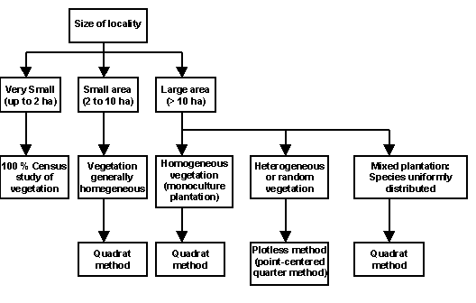
It is also important to include a control plot. This will allow a benchmark comparison of the impact of any management practice (or different periods of protection) with plots which are both 1) unprotected open access, and 2) undisturbed natural forests. The second category of control plot is not easy to locate. In this case, only control plots that are not subjected to any management inputs or protection can be studied. For example, the difference in vegetative regeneration can be clearly observed and measured between a plot where grazing is prevented and a control plot where free grazing is practiced. Control plots should be near the study area, and possess similar soil and topography. The size of the plot depends on the purpose Of the study and the condition, heterogeneity, and size of the forest areas (see Figure, 19). The most common method employed for vegetative analysis is the, quadrat technique. Point-centered quarter method is also described for use in highly diverse areas with randomly distributed Species. It is far easier to estimate crucial parameters such as basal area per ha., species diversity per ha., and standing biomass per ha. using equations through the quadrat method than the point-centered quarter or other methods. The mensuration methods described below are designed to allow the researcher to gain an understanding of species diversity and density, basal area, biomass, and productivity.
Figure 19: Decision Chart for Selection of Method for Study
A quadrat is typically a square plot, however the investigator can select square, rectangular or circular quadrats. In the quadrat method, a specific size quadrat and its replications are marked in the field and vegetation data is recorded for flora falling inside the quadrats. The size and number of quadrats depends on the nature of the study and the vegetative conditions as discussed in the review of site selection criteria. It would vary for different vegetation types because in a given plot, there may be few trees but hundreds of herbs. The investigator may be interested in exploring 0 layers of tree, shrub, regenerating seedlings, and herbs. While the researcher is interested in saving time, the goal is to get as accurate an estimate as possible. Generally, it is Preferable to use more quadrats or quadrats of larger size to provide a better sample. However, statistically even small-sized quadrats or a smaller number of quadrats Property sampled will provide as good an estimate as a fuller census. Keeping in view the limitations on investigators' time and resources, certain quadrat sizes and numbers are generally acceptable as standards as indicated below. Replications of quadrats are necessary to account for variations in soil, moisture availability or topography. In selecting the location of the quadrats, the research team should not choose 'representative' sites, but instead should select randomly in the field to avoid bias. This can be achieved by a random selection on the map in the office, before departing for the field. Also, selection of locations along borders (i.e. of forest and field) should be avoided as be would be subjected to the edge effects and may be larger, more diverse or overused.
After selecting the site and locating the quadrats, the next step is to record relevant observations. In the pre-selected locations, mark the four comers of the quadrat using pegs for the defined dimensions, attaching strings or rope to mark the perimeter of the quadrat. Data to be recorded will vary for trees, shrubs and herbs. Observations should be recorded for all plants lying within the quadrats.
Quadrat Size for Vegetation Studies
|
Vegetation |
Size of quadrat |
No. of quadrats |
|
|
or replication |
Remarks |
||
|
Trees |
50m x 20m |
5 to 8 |
If the soil type, topography, vegetation is highly variable, increase number of quadrats |
|
Shrubs |
5m x 5m |
10 to 16 |
For each tree quadrat |
|
Regenerating trees (seedlings) |
5m x 5m |
10 to 16 |
|
|
Herbs |
1m x 1m |
20 to 32 |
For each shrub quadrat include two herb quadrats |
Data on number of trees, trunk size (DBH), density of coppicing trees, and species distribution are critical for estimating the standing biomass and productivity. Such information is essential to understanding the sustainability of biomass removal, spatial and temporal decisions on extraction, and possible modes for product sharing. Data on the standing biomass, productivity and stump density of coppicing trees would be valuable for decisions regarding economic and institutional aspects of JFM management. Data may be recorded in the format given below:
Tree Quadrat (50m x 20m)
Location: Limbi Quadrat No.: 6 Date: April 4, 1992
|
Name of tree(local or scientific name) |
Girth (GBH) in cms. |
Height Class |
Coppice or Seedling |
Name of Associated Climbers |
|
Terminalia bellerica |
93 |
A |
Coppice |
(see Appendix 2 for a glossary of terms used in this table.)
The plant types of interest are shrubs and smaller tree seedlings or smaller coppice shoots. Tree seedlings include woody plants with less than 30cm GBH and height above 1.4 m. The presence of a large number of tender coppice shoots is an indicator of future growth potential. The assessment of regenerating seedlings will help in decisions on feasible projected quantities of biomass removal for different uses. The smaller quadrats for shrubs and seedlings should be randomly located inside the larger tree quadrats, and marked using pegs and rope.
Shrub & Seedling Quadrat Size 5m x 5m, 2 plots)
|
Shrubs |
Regenerating Seedling or Coppice |
||||
|
Species |
Number |
% around layer* |
Species |
GBH(cm)** |
Height Class*** |
|
Gnidia glauca |
56 |
51-75% |
Grawia glaubra |
12 |
A |
* % categories: 91-100%, 76-90%, 51-75%, <50%
** � 30 cm
*** � 1.4m.; Height classes = A, B, C (see Glossary App.2)
Herb layer vegetation data may not be of interest to all researchers, foresters or local communities. However, in some situations herbs may have medicinal or food value. The small herb plots should be located randomly inside shrub layer quadrats.
Herb Quadrat (1m x 1m, 2 Plots)
|
Herb layer |
% ground cover* |
|
|
Species |
Number |
|
|
Jasminum sp. |
200 |
76-90% |
*25 %, 26 - 50 %, 51 - 75 %, 76 - 90 %, >90 %
Finally, since all species present in a forest patch may not be covered in the quadrats, the investigators should list other plant species (i.e. trees, shrubs, herbs) noticed outside the quadrats when they are working in the field.
Estimation of grass production is of great interest to local communities for its value as livestock fodder or as raw material for rope-making. In terms of management, grass productivity data from patches protected for various periods is necessary to understand the optimal period of protection before yields decline due to shading by trees and shrubs. Grass production can be estimated monthly, seasonally, or yearly. One difficulty in estimating grass production in plots under grazing is quantifying the grass consumed by livestock. To overcome this, the quadrats selected for measurement should be fenced at the beginning of the study and protected from grazing while data is being collected. The size and number of quadrats required for measurement include 5 replications of 5m. x 4m. (20 m2), to provide a total sample area of 100 m2. These 5 replication blocks should be randomly marked in the grassland patch and protected by a thorn or barbed wire fence. To estimate fodder grass productivity, divide each of 5 replications into 12 quadrats of 1m x 1m size. Grass growth occurs during the rainy season and generally continues for 1 to 2 months after the rains end. Depending on the region and when the first rains arrive, one month into the rains should be the starting point for the first harvest measurements. Every 30 days, one plot of 1m x 1m should be harvested in each of the 5 replicates. The harvest technique requires clipping and weighing (in grams) all the grass in each 1m x 1m plot and recording the data. Grass productivity can be expressed as fresh weight since green grass is generally fed to livestock. Gwen grass typically contains about 5-10% moisture, so dry weight can be estimated; alternatively, a sample of 50 or 100 gm of fresh grass can be dried in the oven or sun and weighed.
One of the most common methods of calculating grass productivity is to use the peak month's grass yield as the annual productivity of the plot. The procedure involves adding the dry or fresh weight of each plot to obtain monthly totals from all sample plots, calculating yields/ha for each month, and identifying the highest yield month. By taking the maximum month's yield per hectare and multiplying by the total grassland area, the total grass production available to village livestock if land were protected can be derived.
Aside from fodder, in some areas grasses such as bhabbar (Eulaliopsis binata) are used as raw material in the production of fibre, mats and brooms. Depending on its end use, grass is harvested at specific periods in order to get a desired stalk strength or maturity. Discussions with local collectors and processors can determine the week or month for harvest. Five replicates of 2m. x 2m. quadrats should be randomly laid out and fenced to protect from grazing. Once the appropriate time has been established by local users, the one-time harvest and weighing of above-ground parts can be done. The biomass obtained for this collection week defines the productivity of that plot. An example of how grass data can be analyzed to understand forest management issues is presented in Box 2.
Box 2: Management Options for Bhabbar Grass Lands in Haryana
The fast-degrading Shivalik foot hills are spread over area of 3 million hectares in Haryana, Punjab and Himachal Pradesh. Historically, local communities have had rights to (i) grazing (ii) small timber for housing and (iii) fallen and dry wood for firewood. Under the FD Working Plan (1971-91) in the Morni hills, grazing was prohibited due to server problems of erosion. However, grass cutting with a sickle was still allowed in this area.
In recent years JFM programs have been initiated in the Shivalik hills by the Haryana FD. Various patches under protection for different periods have responded by naturally regenerating. Local communities are noticing significant changes in vegetation; but impression by some were that bhabbar yields were declining, while others felt that yields were increasing with protection. The key management issue facing communities and the HFD was to identify the protection period (and interventions necessary) to maximize grass yield. Grass productivity (bhabbar and other) was monitored using the quadrat method in plots under protection for 0 (control), 1,3,6 and data was recorded in the following format:
Bhabbar and total grass (other grass) yield in dry t/ha/year
|
Control |
1 |
3 |
6 |
10 |
|
|
year |
year |
year |
year |
||
|
Bhabbar grass |
0.33 |
0.39 |
0.77 |
0.85 |
0.45 |
|
Total grass (Bhabbar + other) |
0.67 |
0.67 |
0.86 |
2.8 |
1.11 |
The findings showed that bhabbar yields continued to increase up to 6 years, after which bhabbar and other grass yieldds declined. The decline could be due to several reasons, including increased shading by regenerating Acacia catechu trees and impacts of Lantana infestation. Given these findings, it might be decided that strict protection of grassland is desirable for 5 to 6 years, but after that various vegetative manipulations may be necessary if bhabbar grass continues to be a priority biomass type for the community. For example, Lantana may need to be pollarded or pruned, and lopped twigs used as firewood. Alternatively, the community might decide to protect a part of the land continuously to get firewood and grass, while the remaining part could be treated by removal of Lantana and tree pruning.
Leaf biomass from forests is normally removed in two ways, either by sweeping the forest floor to collect the fallen leaf litter, mainly for manure, or by lopping leaves from standing trees for fodder and plate-making. Leaves often serve as an important raw material for such small industries as leaf plate manufacturing. Leaf litter productivity studies are complex and involve establishing litter traps in the field, collecting litter every fortnight, and separating and drying leaves, and twigs for a full one year. A more feasible and easier option is to use an equation to approximate the leaf litter productivity. The leaf productivity of a tree depends on its age and size, namely its girth (GBH) or diameter (DBH). Based on this relationship between DBH and leaf production, the methodological steps detailed below can be adopted for estimating leaf biomass. In summary, by means of the quadrat method, the technique involves measuring the DBH of the selected species whose leaves are used for plate-making (e.g. Shorea robusta or Butea monosperrma). Frequency distribution for DBH classes can estimate the mean DBH per class and guide the selection of "representative" trees. The leaves of these can then be lopped at maturity and weighed to derive an average for each DBH class. Summations for all classes can obtain a per hectare leaf biomass estimate.
Steps to Estimate Leaf Biomass
|
1. Classify and derive frequency distribution per DBH classes depending on range of DBH values. 2. Estimate mean DBH for each frequency class. 3. Select one "representative" tree in forest with DBH closest to DBH mean of each class (i.e. if 5 DBH classes, select 5 trees). 4. Lop all leaves from representative trees during peak weeks of leaf growth. 5. Convert from representative tree to total for each DBH class and obtain the sum for all classes: Total leaf biomass for DBH Class 1 = Wt. of lopped biomass for representative tree Class 1 x # trees in Class 1 6. Convert the sample quadrat estimate to per hectare projection. (To increase accuracy lop all regrowth 1-2 times during year to confirm annual productivity.) |
It is difficult to predict what percentage of the leaf biomass could be extracted from the plot without affecting nutrient cycling or long-term biomass productivity in any significant way. This would require a series of long-term monitoring studies in different locations. However, some studies have indicated that approximately 50% of tree leaves may be lopped without any appreciable negative effect on the growth or leaf biomass productivity.
The plotless method, also known as the point-centered quarter (PCQ) method (or distance method), is one of the quicker and more reliable methods to employ when examining large forest areas and/or areas with heterogeneous and randomly distributed vegetation. While this method does not fully reveal the plant diversity of a stand, it reveals the dominant species and some of the rarer ones. Density is calculated for a given area by first estimating the mean distance between trees, and then squaring this mean distance to yield the average area occupied by a plant.
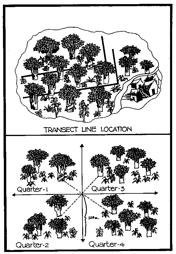
The first step is to point for the transect. In hilly arm it is best to start from ground level and proceed up the hill, while in flat areas it is preferable to begin at the edge of the forest. If there is a large variation in vegetation, such as in the valley and upper reaches of a hill, or if there are clear cut variations in the tree density in different patches, the patches should be considered separately with different transect lines. Normally, two transect lines of approximately 1 km. in length should be used. Ten points along each transect at distances of 100 m. can be selected for measurement. Accuracy increases as the number of points increase. If the forest is small, points should be chosen at shorter 50 m. intervals. Selecting points at 100 m. or 50 m. intervals can help avoid bias. If the forest is small and a 1 km. straight line is not possible, a perpendicular line can be taken as shown in Figure 20. At each interval, the following data format and methods can be adopted:
Data Format for PCQ Method
|
Point number & quarter |
Name of tree |
Distance from central point (m) |
GBH* |
Height class |
Occurrence of climber |
Coppice or seedling |
|
1a |
Terminalia paniculata |
4.09 |
19 |
A |
None |
Seedling |
|
1b |
*Select only trees with > 30 cm GBH; If more than one shoot or coppice, take each GBH measurements.
1. Using a compass, walk along a straight line with a stick or rope to indicate the transect.
2. At each 100 m. point, establish a perpendicular line with the stick, resulting in the formation of 4 quarters.
3. At each 100 m. intersection point, record the distance of the tree nearest to the intersection in each of the four quarters (see Figure 20).
Figure 20: Transect Line Location
The PCQ methodology for studying shrubs, regenerating seedlings and herb vegetation is similar to that of the quadrat method but a few points need to be considered. From the four quarters formed by the transect intersection, randomly select two of the quarters and then two shrub quadrats within each of the two quarters. A number of points should be located along the transect where shrub and herb layers are to be measured. Specifically, if two transacts are used, select 3 points (3rd, 6th and 9th) on the first and 3 points on the second transect. In the plotless method, every species present in a given area may not be covered along the transect points. Thus, all plant species outside the transect points should also be listed during the fieldwork.
Canopy cover is defined by the extent of ground area covered by the spread of tree branches and leaves. It indicates the openness of the ground to sunlight, and suggests the gaps available for natural regeneration or grass growth. Good canopy cover suppresses grass and herb plant growth. Thus, canopy cover data is important for decisions on vegetation manipulation (pollarding, pruning, removal) to encourage grass productivity or shrub growth as well as to identify shade-loving plants. Canopy cover can be estimated by recording the percentage overlap between adjacent tree crowns directly above a large number of points in the forest. One can either study the development of the canopy over time in the same plot, or conduct a cross-section comparison of patches under varying modes or periods of protection and management. A rapid technique to estimate canopy closure involves selecting a representative point in the forest to start, stopping every 5 m. along a compass line to directly took above and observe the tree canopy, and recording 30 observation points for the sample to obtain a mean score and percentage for canopy closure (see data sheet and Figure 21).
Data Sheet for Crown Canopy Scores
|
Observation Points |
'0' |
1 |
2 |
3 |
|
1 |
x |
Figure 21: Estimating Canopy Cover
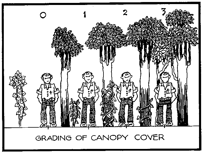
Figure 22: Grid Projection and Canopy Structure Meastruments
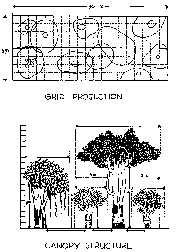
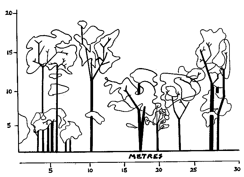
Figure 23: Vegetation Profile in a Mixed Forest in Huliyurdurga, Karnataka
The vegetation in a regenerating plot may consist of tall trees (spreading or non-spreading), dwarf trees, trees growing under the shade of tall ones, shrubs, herbs, etc. Vegetation profiles indicate the arrangement or structure of the above-ground forest ecosystem, depicting both the vertical and horizontal spread of different plant types. Data on height and spread of trees or shrubs is necessary to make management decisions which maximize the type of biomass the community requires. From a given patch, the community may desire grass as fibre, shrubs as manure, tree twigs as fuel, tree leaves for plate-making, or a combination of these. The vegetation profile, in combination with community demand and preference information, can help determine optimal vegetative manipulations to achieve management goals. A vegetation profile can be prepared for each type of forest and for two types of vegetational differences: (1) those reflecting structural changes over the years in a given forest patch, and (2) cross-sectional comparisons of similar patches under various ages or periods of protection. To rapidly assess forest structure, the following methods are suggested:
Vegetation Profile Assessment
|
1. Select a representative strip 30m. X 5m. 2. Fix the central line of the strip and mark the axis on the graph paper. 3. Walk the central line, marking position of each tree within the strip on graph paper with respect to the central line (see Figure 22). 4. Record for each tree GBH or DBH, height, bole length and major first branch 5. Mark the canopy area by measuring at least 4 points of the crown, mark the shape of the canopy, and measure the distance between trees (see Figure 22). 6. Based an this information, draw a forest structure profile. The vegetation profile indicates the presence of tall trees in the height range of 10-20m. and a few trees in the lower canopy. Most are characterized by a medium spread. The profile illustrates a healthy status of mixed forest with trees of various heights and minimal lopping (see Figure 23). |
As described earlier, the standing biomass or biomass productivity of trees is the most important parameter for making management decisions on the quantity of sustainable tree biomass extraction. Biomass is the wood weight or volume of trees (including stems and branches) at a given time (standing) or over a period of time (productivity) in a prescribed area. One of the two methods of estimating biomass is the harvest method, in which all trees are felled in the selected number of simple quadrats and their weight estimated. This technique is not often practical or desirable as it involves the felling of a large number of trees. Biomass can also be estimated using DBH and height as indicators of tree volume or weight. Several studies have established a quantitative relationship between the weight of certain trees and their DBH and height, however such biomass estimation equations are currently only available for a limited number of important tree species. The equation used is as follows:
Biomass = b + a (D)2H
where D = DBH, H = Height, a and b = constants (species specific)
Alternatively, based on data from a number of forests in India, a rough estimation of standing biomass is also possible by using basal area per hectare data:
Total biomass = b + a (Basal area in m2/ha)2
where b and a are given constants as follows,
a = 35.23, b = .156 [SE = .0351) [R2 = .68]
It must be noted that although standing biomass is a critical parameter, it is also one of the most difficult measurements to estimate accurately. Most importantly, no management decision should ever be based on one such parameter alone, but instead must consider the range of vegetational institutional and economic factors influencing the system. In West Bengal, researchers have attempted to estimate sustainable firewood and leaf yields using the methods described in Box 3.
Box 3: Sustainable Harvest of Firewood and Leaves From Sal Forest
In the regenerating sal forests of West Bangal, the JFM committees are interested in assessing the quantity of wood for fuel or leaves for plate-making that can be harvested sustainably. Basal area of Sal (Shorea robusta) forests of different ages in a village is given below:
|
AGE |
Basal Area m2/ha |
|
5 years |
7.6 |
|
18 years |
18.7 |
|
41 years |
20.4 |
Standing Biomass: Basal area in m2/ha can be calculated for sal forest of given ages. To approximate the standing biomass in tons/ha, the basal area can be substituted in the following equation:
|
Standing biomass |
= 39.156 + 0.1011 (BA) 2 |
|
(SE : 0.01) |
|
|
R2=0.91 |
For example, if an 18-year old sal has a 18.7m2/ha basal area, its standing biomass would be 74.5 t. Based on preliminary findings which estimate sustainable extraction levels may lie around 3-6% of standing biomass, the community could decide to harvest about 4-5% (3.5 tons) of this standing biomass as firewood.
Leaf biomass estimation: Leaf productivity can be estimated for a sal forest of a given age using the following equation based on basal area:
|
Leaf productivity |
= 1.456 + 0.1219 (BA) |
|
(SE: 0.019) |
|
|
R2 = 0.79 |
If the basal area of the 18 year old sal plantation is 18.7m2/ha, the leaf productivity would be 3.7 dry t/ha/year. the dry weight of leaves can be converted to fresh weight by adding 75% water weight or dividing the dry weight by 0.25. Thus the fresh weight of leaves for the 18-year old plantation would be 14.8 t/ha/year. Based on field studies it may be possible to estimate that about 30-50% of the leaf biomass could be removed sustainably for plate-making. In other words 4 to 7 tons leaves could be lopped annually.
Understanding the structure and function of the natural forest ecosystem is essential to establishing sustainable use systems. Growing rural population pressures throughout India will require that many natural forests are utilized intensively to meet local needs. It is important that while meeting resource demands, the forest's environmental functions, including soil conservation, biodiversity, local hydrology and microclimate, will also be sustained. While FDs and silvicultural researchers have gained considerable knowledge regarding the growth patterns of important timber species, much less is known concerning NTFPS, regenerating forest ecosystems, and how they change over time. Specialized research that indicates how natural forests can be sustainably harvested to generate a steady flow of products is critically needed. Forest user communities may possess insights regarding forest ecosystem regeneration and how forests might best be managed. Combining conventional vegetative research techniques with local knowledge, based on community experience, may be the most effective way to design management systems that meet both environmental and economic goals.
At the same time, while PRA and diagnostic vegetation studies conducted at one point in time can help initial management options, the local community as well as the FD will greatly benefit by monitoring vegetation dynamics, including wood and NTFP removals, over longer periods of time. Long-term monitoring plots could be set up be the local community, and with guidance from teachers, local students and other interested community members could monitor forest ecosystems using the proposed baseline methods. Future volumes of the Field Methods Manual series will attempt to document new, more effective methods to assess vegetative conditions and change through rapid appraisal and long-term monitoring.