Indonesia possesses 60 percent of all forested lands in Southeast Asia and an even greater proportion of the remaining primary rainforest (
FN 1). Forests are of immense importance to the country, with nearly 75 percent of the land area under official forest cover. This distinguishes Indonesia as the third largest tropical forested area in the world (after Brazil and Zaire) (see centerfold map, pp. 30-31). Rich biological diversity characterizes Indonesia's forest ecosystems, including over 10,000 species of trees, 1,500 types of birds, and 500 varieties of mammals (FN 2). Forests also support millions of indigenous tribal peoples who have historically resided in the interior reaches of the outer islands, as well as a growing number of migrants from densely populated Java. At the same time, logging of valuable tropical hardwoods has contributed significantly to the generation of foreign exchange, providing strategic impetus to the acceleration of the Indonesian national economy, especially during the 1970s and 1980s.Due to the multi-purpose importance of the forests, considerable attention has been given to the formulation of forest use policies in Indonesia. Nonetheless, the outcome of these policies has not always been consistent with the intention of national planners. Currently, 34 percent of the nation's forest area has been reserved for both protection forests (21 percent) and national parks (13 percent). Another 21 percent of the forested area is allocated for conversion to agriculture, settlements, and industrial purposes (
FN 3). The remaining 45 percent of the forest area, or approximately 64 million hectares, is designated production forest and is currently leased to approximately 500 concessions which each average 100,000 hectares in size, with some lessees holding over I million hectares.Officially, 144 million hectares is entrusted to the Ministry of Forestry. Aerial photos from 1981-82 indicate that only 76 percent of this land is actually forested. This still represents 60 percent of the country's surface area, although it continues to be depleted. Current estimates suggest that deforestation has been progressing in Indonesia at a rate of 700,000-1,200,000 hectares annually (
FN 4). In the early 1970s, the UN Food and Agriculture Office (FAO) estimated that forest clearing denuded 300,000 hectares per year, indicating that forest utilization has been accelerating substantially over the past two decades. Recent studies have attempted to break down annual deforestation rates by cause, citing smallholder conversion (500,000 ha.), development projects (250,000 ha.), and logging and forest fires (1 80,000 ha.) (FN 5). Estimates from the World Bank cite a rate of 250,000 hectares lost each year to overlogging or poor logging practices and 750,000 hectares lost to fires, development projects, and agricultural conversion (FN 6). However, the accuracy of these statistical estimates is questionable. While providing indications regarding the scale of the problem, statistics do little toward illuminating the processes and outcomes of various forest-use practices. The findings reported in this study demonstrate that the rapid changes in Indonesia's forest ecosystems are often a result of a progressive series of human activities and natural events. The case studies presented also show that these activities affect forests in different ways, each with implications for forest regeneration and survival. The events and agents that are currently reducing Indonesia's forest cover are often poorly understood. While the rapid deforestation of the past two decades has been frequently attributed to local people practicing "slash and burn" farming, a growing body of experience indicates that Dayak rotational swidden agriculture has been one component of a time-tested, integrated resource-use system that was highly sustainable, especially compared to current timber utilization practices and commercial plantations. These case studies attempt to document the processes of forest disturbance and the ecological changes that result. The research also highlights the stages and processes of natural forest regeneration after certain types of disturbances, suggesting potential strategies for rehabilitating and managing these degraded ecosystems in the future.
Due to an active timber utilization industry, the sequential ecological effects of a series of natural fires, and growing migrant pressures, it is estimated that one-half of Indonesia's deforestation during the 1980s occurred in Kalimantan. The province of East Kalimantan is currently the center of the commercial timber industry, supplying nearly 25 percent of the nation's commercial needs, or approximately 6.5 million logs per year (
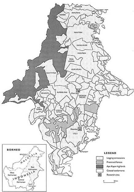
FN 7). The timber is produced by over one hundred concessionaires currently operating in the province. Over 50 percent of the province (9-8 million ha.) was leased to concessionaires in the early 1970s (see Figure 1) (FN 8). In the preparation of the type of forest use map presented in Figure 1, very little information is generally available to document existing community settlements and their ancestral (adat) land rights. It is estimated that nationwide only 20 percent of the agricultural land has been titled, while the mapping of community rights to forested areas for hunting, gathering, and rotational agriculture has not yet been initiated. As a result, the forest-use planning agreement (TGHK) process has often been unable to accurately demarcate community boundaries, and traditional rights are not incorporated in these provincial land-use plans. Migrant community needs and claims over land are typically unrepresented, except in government-sponsored transmigration sites. This situation has often generated conflicts between larger commercial users or state-sponsored development projects and local communities, as illustrated in the following case studies.After twenty years of forest utilization in East Kalimantan, most of the leased-out area has already experienced an initial round of selective felling. In those areas where concessionaires adhered to regulations which limit them to only a few of the largest diameter trees in each hectare, forest ecosystems have suffered less damage. Nonetheless, depending on the extraction practices utilized, up to 40 percent of the standing stock may be damaged during timber operations (
FN 9). Many concessionaires have had inadequate capital to carry out logging operations according to guidelines. Instead, they have subcontracted to small operators who fail to follow the regulations. Other contractors, who have the resources to harvest less destructively, have no incentives to follow regulations. In some cases, the Ministry of Forestry has begun to withdraw logging rights (Hak Pengusaha Hutan-HPH) from concessionaires who have violated agency felling and extraction procedures. Furthermore, concessionaires have difficulties protecting their thirty-year lease areas from subsequent illegal cutting, which often takes place once a road is built for the initial felling.
The purpose of the research in East Kalimantan is to examine patterns of forest disturbance, community forest use and protection, and natural regeneration. Two contrasting research sites were selected. The first represents migrant communities within a few hours of the Samarinda-Balikpapan highway. The site is surrounded by a number of development projects and a large logging operation.
Figure 1
Logging Concessions in East Kalimantan, 1970's
The first site was chosen to investigate land-use changes in highly pressured forest areas. The village of Datarban is situated adjacent to the P.T. ITCI logging concession. Datarban and the ITCI concession are located northwest of Balikpapan and the provincial capital of Samarinda in a zone with growing population pressures and expanding market access. The entire Lower Kutai area, in which Datarban lies and which encompasses the Mahakam River delta, was leased to concessionaires in the early 1970s. The area has undergone extensive felling. In the 1980s, many of the logged-over concession lands were reclassified for use as estate crop plantations, transmigration sites, and coal mines (see Figure 2). Families residing in Datarban sense that they are increasingly squeezed between these competing, often conflicting land-use activities.
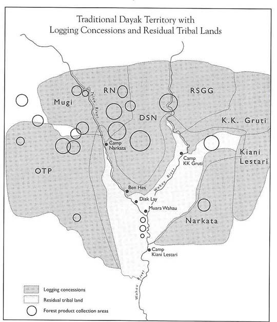
The second research site is the traditional community of Diak Lay, located to the north of Samarinda, approximately four hundred kilometers up the Mahakam River. Communities of Wehea Dayaks settled in the area over the past several hundred years. The lives of these communities had changed little until the last twenty years, when eight logging concessions initiated operations around their traditional lands (see Figure 3). Georgia Pacific entered the area in 1970 and was followed by seven other concessionaires. Since negotiations have never been held among the Indonesian government, the concessionaires, and the local communities, conflicts over resource rights continue to be a major problem. This case attempts to examine how traditional forest use Systems differ from commercial timber operations and, given the often competing needs and rights of local communities and concessionaires, how forest resources might be better managed in the future.
Figure 2
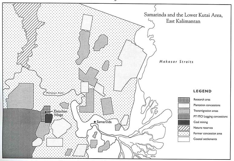
Figure 3