"Before this program began, forest use in the watershed was out of control."
-"Uncle" Chan, Karen hill farmer in Nam Sa, December 1992
After a lengthy debate at a recent meeting of the Nam Sa subwatershed Network forum, community representatives decided to ban chainsaws in their forested homeland. Only a single village out of ten member villages contested the idea. This decision illustrates just one of many deliberations and outcomes of a three-year-old program to establish community controls over the rich forest ecosystems that have been rapidly disappearing in the Sam Mun mountains, seventy-five kilometers northwest of Chiang Mai in Northern Thailand (
see Figure 2).The northern watersheds of Thailand play an important role in supplying water to the nation's central rice bowl. Planners have been concerned that the hydrological function of these critical watersheds, with the second highest regional rate of deforestation, are being under-mined. Similar to the Northeast, the forests of the North have been under growing use pressures from lowland populations migrating into the upper watersheds. However, unlike the Northeast, a steady stream of hill tribes has also migrated into the highlands to practice shifting agriculture. In recent decades, political instability in Laos and Burma has increased the flow of highland tribal people. While many of these hill tribe communities have been engaged in opium cultivation, foreign governments and international agencies have placed strong pressure on the Thai government to control production. Numerous crop substitution programs and resettlement schemes have been implemented since the 1980s, showing some success in decreasing opium growing and responding to the needs of highland tribals. However, the midland tribals, among the poorest in the region, have been relatively ignored. Furthermore, given serious upland deforestation and associated environmental deterioration, the fundamental problems of sustained productivity persist.
Based on the urgency of protecting the upper watersheds of the Northern region and the relative failure of programs to reverse the processes of deforestation, until recently the government has emphasized resettlement of midland and highland tribal people outside areas designated as national parks, wildlife sanctuaries, or Class 1 watersheds (STK program). However, resettlement has not proceeded on a broad scale due to community protests and limitations on available land for relocation outside the steep watershed areas. The case of Nam Sa offers an alternative to resettlement, illustrating an opportunity for government to forge partnerships with local communities to protect critical watersheds and important forest resources without disrupting local settlement patterns. The Office of the Prime Minister and the RFD have recently initiated a Northern Watershed Rehabilitation Program, which might draw upon the significant experience of Nam Sa and extend its forest stabilization strategies through much of the upper North region.
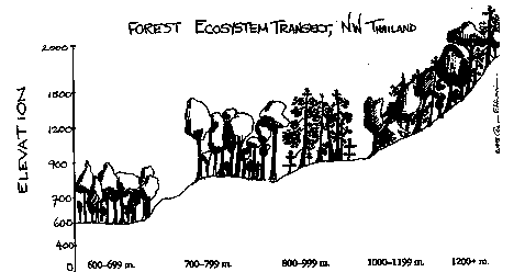
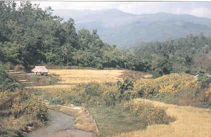
The 2,000 square kilometers that encompass the Sam Mun watershed area are inhabited by sixty ethnically diverse village hamlets of Karen, Lisu, Akha, Hmong, Unannese, and local Thai-speaking peoples. The communities are interspersed amid the Sam Mun mountains, a rugged range of ridgetops and narrow valleys which fluctuates from 700 to 2,000 meters above sea level. Although the villages are economically poor, they have been blessed with abundant natural resources, including some of the Kingdom's most majestic mountain forests. Loamy soils underlain with granite and limestone support a range of forest ecosystem types, varying from dry deciduous and teak to towering dipterocarp giants, pine, and hill evergreen forest (
see Figure 9). The area receives about 1,700 millimeters of rainfall annually. Characteristic of Northern Thailand's hill region, the ethnolinguistic diversity is mirrored in the different farming systems practiced in the region. Based on estimates in 1987 that 800 hectares of the 2,000-square-kilometer Sam Mun watershed was under opium production-yielding 15-20 metric tons of raw opium annually-the watershed was targeted by Thailand's Narcotics Control Board and the UN Fund for Drug Control. Among the sixty hamlets in the watershed, it is primarily the highland Hmong, Lisu, and Akha who have engaged in opium cultivation. However, in coordination with the RFD as lead agency, project planners realized that the problems of the region were not simply ones of opium production. Over the past twenty years, this once remote area has been shaken by war on the Burmese border, opium trafficking, commercial logging, in-migration, and the commercialization of agricultural systems. These changes have resulted in steady deforestation, severe soil erosion, and periodic fires which have rapidly destroyed the environmental stability and productivity of the uplands. Programs to simply generate more cash would hardly help wean villagers away from opium cultivation if they were unable to stabilize their natural environment in the transition.
|
Ecozone |
Mixed dry deciduous and teak |
Dry dipterocarp |
Pine |
Mixed pine and evergreen |
Hill evergreen |
|
Tree Species |
Dendrocal-amus spp. Tectona grandis Pterocarpus Macrocarpus Irvingia malayana |
Shorea obtusa Shorea floribunda Xylia xylocarpa Terminalia odorata Terminalia tomentosa Shorea siamensis |
Pinus kaseya Pinus merkussi |
Pinus kaseya Castanopsis Ficus spp. Hopea odorata |
Castan-opsis Quercus spp. |
|
Crop Type |
Wet rice |
Wet rice, taro |
Dry rice, opium, cabbage, corn |
||
|
Ethnic Group |
Northern Thais |
Northern Thais and Karen |
Hmong, Lisu, Lahu and Aku |
||
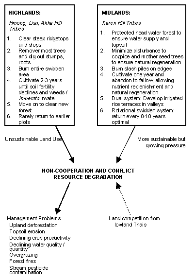
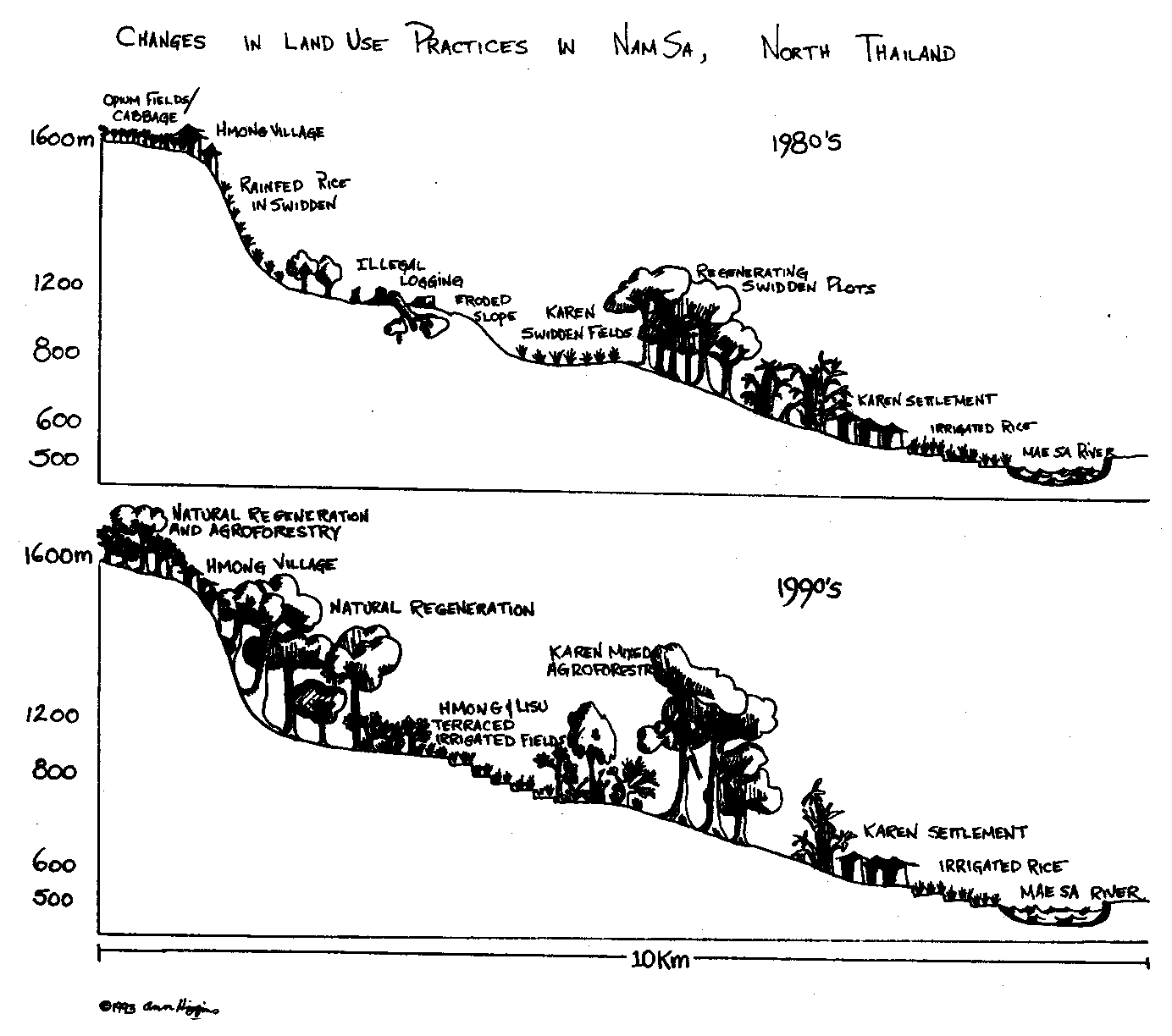
Beginning in 1986, collaborative field studies sponsored by the Ford Foundation were undertaken by social scientists at Chiang Mai University (CMU) and RFD program officers. The work helped to identify important conflicts between the highland opium-cultivating communities and the midland Karen and lowland Thais. One of the findings confirmed research conducted over the past decade which documented differences in shifting cultivation strategies among hill tribes. The upland tribes practice a form of swidden cultivation involving the clearing of steep, erosion-prone ridgetops and exposed upper slopes which have good sunlight and drainage. The communities remove most of the trees, dig out rootstock and stumps, and burn the entire swidden area. They then farm these fields for 2-3 years or until the soil's fertility is badly depleted and weeds such as Imperata grass invade. Abandoning the plots in an ecologically disturbed, inhibited state of succession, upland tribals rarely attempt to return one day to reutilize them. Instead they move on to clear new vulnerable uplands, repeating the process of forest overexploitation, degradation, and conversion to grassland.
In contrast to the often unsustainable land-use system practiced by the more recent migrant highlanders, the midland Karen --some settled for over a century -- adopt a dual production system. Both shifting and sedentary, the system combines midland swidden with lowland irrigated paddy farming. First, the Karen protect headwater forest to ensure topsoil stability and a consistent supply of water to their lowland paddy fields. In swidden field preparation, they take care to minimize disruption by burning on field edges and leaving coppicers and mother seed trees in an effort to ensure natural forest regeneration. The Karen rarely cultivate a field for more than one year. Thus forest regrowth is often rapid, sufficiently rejuvenating soil fertility so that the newly regenerated forest can be cleared again after 8-10 years of fallow. The Karen move less frequently than the highland tribes due to their permanent lowland paddy in the valley bottoms and tendency to return periodically to farm old swidden fallows again. Their less land-extensive, rotational swidden systems have historically proven ecologically sustainable (see Figure 10).
Differences in Shifting Cultivation Strategies, North Thailand
The highlanders' swidden practices have subjected the Karen to the negative downstream impacts of forest degradation, often bringing them into conflict with upland tribal groups. The Karen are also being squeezed from below due to increasing pressure from lowland Thais who migrate into the watershed and compete for irrigated rice lands. At the same time, none of these communities has had any legal resident authority or rights over the forest resources of the watershed since the area is formally designated Reserve Forest Class 1 Watershed under the jurisdiction of the RFD.
The Sam Mun watershed project strategy adopted an unusual approach by deciding that communities must be given rights and responsibilities to effectively stabilize and manage the forest environment. The CMU-RFD collaborative experiment in Nam Sa subwatershed of the Sam Mun began the initial testing of this unconventional strategy.
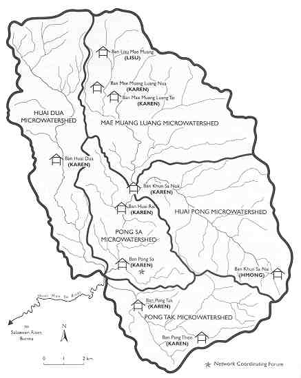
Nam Sa is one of the subwatershed areas located in the Pal watershed of Mae Hong Son Province, draining into Burma's Salaween River. The Nam Sa subwatershed encompasses five distinct microwatersheds, each an average of 20-30 square kilometers (see Figure 11). Nam Sa is inhabited by 10 hamlets (muban) of Karen, Hmong, and Lisu hill tribes. In each microwatershed there are 1-3 hamlets, each comprised of 35-50 households, for a total population of 2,000 people (
see Figure 12). The Hmong and Lisu reside in the uppermost reaches of the watercourses.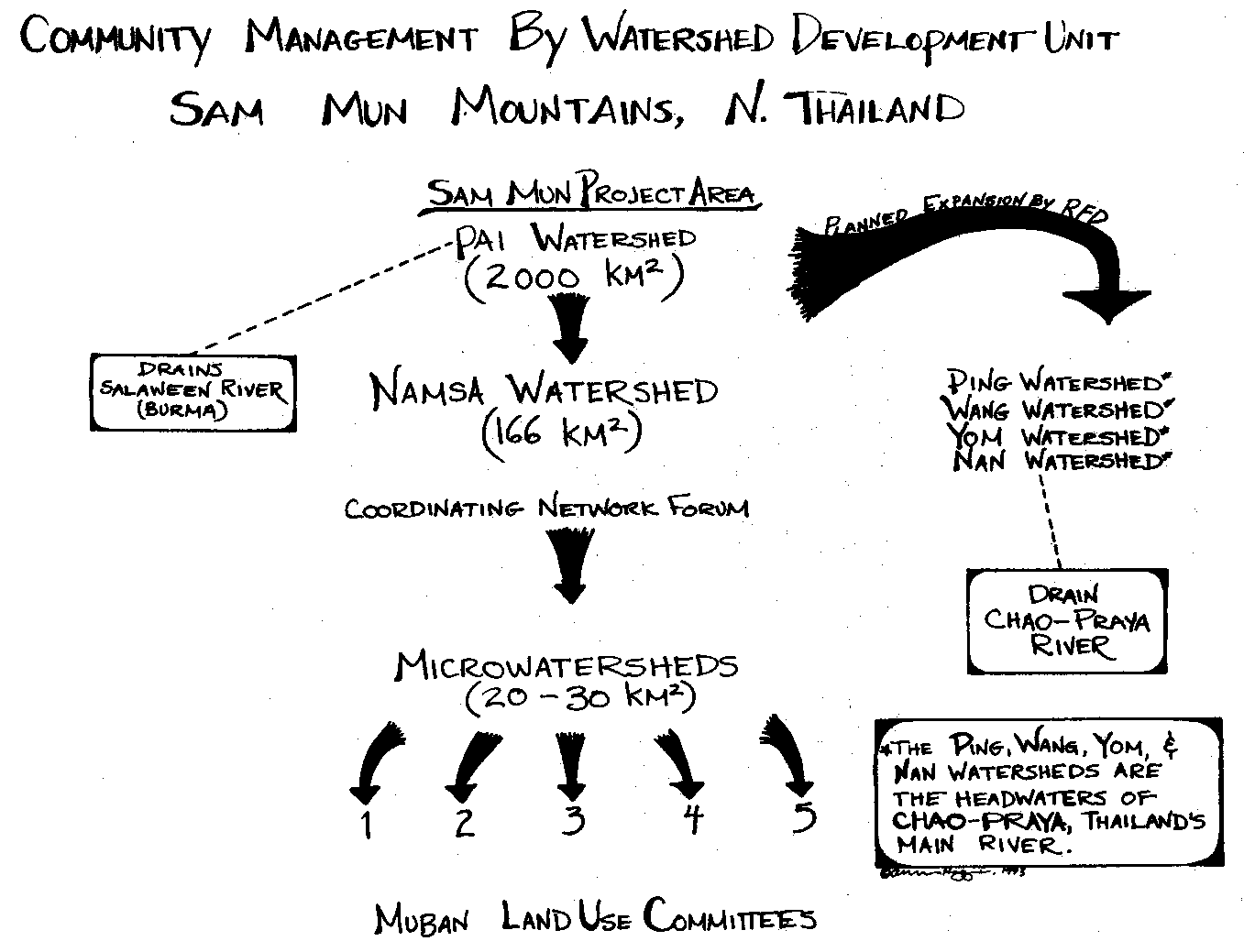
A small dirt road built in 1985 winds its way over the ridgetops and along the valleys, connecting a few of these communities to the outside world. Log bridges crisscross the many perennial streams that drain the subwatershed. Local communities selected their village sites and names based on the five streams that drain the Nam Sa (e.g., Huai village is located next to the Huai Dua stream). The project team felt it might help communities protect and manage their entire subwatershed if the larger geographical area were clearly demarcated by smaller tributary microwatersheds, hydrological units with which the hill tribes were already familiar.
|
Community Managed Microwatersheds in Nam Sa
Location: Pai Watershed, Nam Sa Subwatershed, North Thailand |
Recruited early in the project in 1987-88 to work as community extensionists, two young community organizers (COs) took up residence in the Nam Sa subwatershed. They began visiting the settlements to discuss conflicts, communication difficulties, and resource management needs. In a gradual and painstaking process, it took two years for the COs to succeed in transforming the initial relationship of skepticism and distrust toward them to one of trust and mutual rapport with villages historically isolated from any outside intervention. Only then could the organizers move into serious discussions of watershed management by encouraging communities to organize and actively participate in protection and coordination of land -- and water-use decisions (
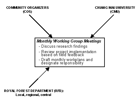
see case study, p. 37).From its inception, another important feature of the project has been the institutional mechanism of monthly "Working Group" meetings. On the program level, the Working Group effectively coordinates and systematically monitors the roles of key project collaborators at all levels, from the field to the central forest office. Meetings are conducted to review field research findings, adjust the program accordingly, assess indicators of progress and failure, and draft monthly workplans by designating specific responsibilities to project staff (
see Figure 13).At the field level, project officers determined that the villagers might be most successful if they conducted microwatershed planning through village (muban) committees, while also developing a subwatershed Network forum to coordinate intervillage decisions and management activities among the ten mubans. The primary role of the COs has been to assist the hamlets in establishing Muban Land-Use Committees and a subwatershed Network coordinating forum comprised of elected village representatives.
Among the first activities undertaken jointly by the COs and communities was the construction of large, three-dimensional maps based on information from topographical maps and aerial photographs. Khun Rath, the kamnan of the subdistrict, notes that in his village of Pong Sa, the COs taught community members not only how to construct a three-dimensional map of their microwatershed, but also how to utilize the information. Constructed on a scale of 1:5,000, each map took 2-3 weeks of community work-cutting, stacking, and painting raised cardboard with different colors to indicate ridge and valley boundaries, fields, forests, and streams. Initially, villagers had some difficulty orienting to the topographic maps. This changed as they worked on the watershed model, gaining experience and confidence in map interpretation.
Yan Yong: A Community Organizer's ChallengeA twenty-nine-year-old graduate of agriculture, Yan Yong was hired four year ago by the RFD as a community organizer (CO) for the Sam Mun project. His mandate was to help the villages in the subwatershed develop a participatory resource management system. After two months of training by social scientists at CMU and by RFD staff, he was assigned to Nam Sa with one other CO. Yan Yong recalls his struggle in the first half year in the field: The villagers did not trust me and were reluctant to speak. Earlier, when the foresters had attempted to reforest degraded grasslands, the villagers would pull out the seedling. All I could do was to keep talking with them about their lives and problems. Traveling among my three villages, eating and living with the families, I was trying to build trust and to respond to their fears and needs. Two years later, he climbed to the top of the ridge with a group from the village and began discussing land-use problems, pointing out the visible ecological differences between conservation farming practices and unsustainable swidden systems. This was Yan Yong's first breakthrough and a turning point in the development of a new relationship between the RFD and the community. As a CO, he feels that his most important role is sensitizing the community to resource management problems and potential strategies to resolve them. By helping establish a Network forum for discussion in Pong Sa, Yan Yong has tried to create opportunities for intervillage cooperation and exchange. The main resource management issues in the subwatershed involve the shifting from upper catchment swidden fields to permanent farms in the lowlands. According to Yan Yong, about 80 percent of the households are in the process of shifting while 20 percent are cultivating their highland swiddens for another year during the time-consuming process of constructing terraces and irrigation channels for their lowland fields. The preparation of rainfed fields also takes longer because they now are planted along the contour to minimize erosion. Community members, especially the Karen, are assisting upland groups in the transition process. Land-Use Committee members are also working avidly to tackle the pesticide problem. The owner of a pesticide manufacturing company strongly influenced farmer attitudes by writing a letter to the newspaper just prior to his death apologizing to communities for the problems his product (Gummoxone) had caused. As evidence of fishkills from stream contamination mounts, more farmers are practicing organic pest control measures. Yan Yong recalls the early efforts he made in urging the villages to conduct systematic monthly meetings to discuss resource use needs and management options. Today, he reports that the Muban Committees and Network forum have become institutionalized and self-reliant. He now can stand outside the meeting hall and simply monitor the discussions. Taking responsibility for their own future, the villagers are becoming more confident and empowered to solve by consensus their resource management problems. |
The interactive process of creating the three-dimensional maps led to numerous discussions of resource use in the subwatershed and helped the community focus its attention on the spatial location of problems and management options. The maps have cultivated a keen sense of ownership, interest, and responsibility among the village members, assisting them in visually understanding the upstream- downstream river linkages and serving as discussion tools for land-use planning at monthly meetings. With the maps as reference points, local land-use management plans have been developed for each microwatershed. Reaching a consensus on a new management plan generally takes Muban Committees 2-6 months. Detailed sets of management rules and regulations to implement the plans have also been developed by the village committees, although changes and refinement of the regulations are an ongoing process.
Thailand Upland Social Forestry Pilot Project:
Working Group Structure
|
|
OBJECTIVE: |
RFD-COMMUNITY-CMU collaboration to develop participatory land-use management plans |
|
|
STRATEGY: |
Learning process approach centered on village community organizers and Working Group structure |
Interdisciplinary diagnostic research, combined with the RFD's extension activities through the COs, has led to improved understanding of the subwatershed's major resource management issues and of community strategies to address them (
see Figure 14). One of the major land-use changes promoted by the RFD and COs has been to encourage highland villages to abandon ridgetop and upper slope opium and rice cultivation and to shift their homes and fields to the mid -- and lowlands. Offering interagency technical assistance, the initiative is helping upland communities construct terraced, irrigated rice fields along the bottoms of the tributary stream valleys. The UN Fund for Drug Control program contributes a financial incentive of 500 baht ($20) for each rai of irrigated rice land created, to be deposited into the muban development fund. However, the idea of moving downslope was initially rejected by the Hmong village of Khun Sa Nai. Reluctant community members were inexperienced with wet rice cultivation and did not wish to move their traditional homes. Eventually, with the guidance of the COs, a compromise solution was reached. The Hmong agreed to shift their fields downslope in exchange for maintaining their ridgetop home settlements.After gaining assistance from the RFD and the midland Karen, who understand well the ecological benefits if they cooperate, the Hmong have replanted their upland fields with fruit trees, which they are now protecting. They are currently constructing terraced fields and building diversion dams and canals to their new irrigated paddy lands. In anticipation of a shift downslope, the Lisu village is also preparing lowland rice fields situated two hours from their homes. An RFD project officer predicts that the complete transition of highland field cultivation to lower lands in Nam Sa will require another two years. The availability of adequate favorable lands for these shifts and land conversions to lowland irrigated paddy has undoubtedly been a decisive factor in the progress. Meanwhile, the hill tribes are working with the RFD to turn their former ridgetop and upper slope fields into mixed agroforestry plots. In areas where Imperata grass has not taken hold, good natural forest regeneration is underway (
see Figure 15).Management Issues in Nam Sa
|
Problem |
Strategy |
|
1. Upland deforestation |
- No clearing steep slopes or ridgetops - Agroforestry, reforestation - Protection to enhance natural regeneration - Shift ridge and upland swidden to lower lands - Ban chainsaws |
|
2. Soil erosion |
- Soil and water conservation practices (e.g., terracing, agroforestry, alley cropping, mulching, vegetative bunding, contour farming) |
|
3. Declining agricultural yields |
- Shift upland fields downslope - Contour farming, terracing, crop rotation - Irrigation - Decreased pesticide use |
|
4. Decline in water quality and quantity |
- Strict head water forest protection - Natural forest regeneration and reforestation/agroforestry - Soil and water conservation techniques - Minimize upland grazing pressure - Reduce pesticides |
|
5. Chemical pollution in streams (pesticides, fertilizer) |
- Reduce pesticide use and substitute natural biocides - Adopt organic farming with integrated pest management techniques - Plant mixed tree crops, including nitrogen-fixing species - Reduce chemical fertilizer, use green manure |
|
6. Forest fires |
- Voluntary community patrols, increase in dry season - Firebreak around fields, fines for escape from swidden |
|
7. Overgrazing and livestock crop damage |
- Ban free "open access" grazing, adopt stall feeding - Fencing of ecologically vulnerable areas - Regulate rotation grazing |
One of the major problems faced by upland communities under-taking this shift in land-use and production systems is the loss of income in moving away from opium cultivation and (in some cases) cabbage. Opium currently brings 10,000 baht ($416) per joy (1 joy = 1.6 kg.), and most fields yield 2-3 joy per rai. This means that a six-rai plot can generate up to 180,000 baht ($7,500). However, apart from powerful economic incentives, a number of disincentives to opium cultivation have mounted over recent years. Since opium-growing is illegal and subject to police raids, farmers must find isolated locations for cultivation and risk the chances of crop destruction and arrest. As Nam Sa was opened up to the outside world by the road in 1985 and the UN crop eradication program was initiated in 1987, these risks have grown. Furthermore, the entire subwatershed is designated reserve forest, and the hill tribes understand the basic tenure insecurity this implies. Should they choose not to cooperate, the villagers fear they may face total dislocation, a policy vigorously pursued until recently by the government in the North and Northeast with the Khor Jhor Khor forest resettlement program. Interestingly, despite the transition away from opium, it is estimated that the average annual household income in Nam Sa increased from $250 in 1987 to $600 in 1992 (
FN 11). This increase in income has resulted in part from private sector involvement in marketing and production improvements for cash crops and livestock. Nam Sa leaders today report that no opium has been cultivated in the subwatershed since 1990.Cabbage has also been an attractive commercial crop, and its intensive cultivation has been encouraged by certain agencies as a substitute for opium. While input costs for seed, fertilizer, and pesticides are high, cabbage can generate 20,000 baht or more per rai ($4,800 per hectare). However, farmers in Nam Sa have become increasingly alarmed over the dangers of heavy pesticide application, which the crop seems to require. In response to a series of fishkills from stream contamination, community committee members are now pressuring farmers to reduce pesticide use in cabbage cultivation.
Forest products continue to provide an important source of supplemental food and medicine for the communities of Nam Sa. A wide variety of forest leaves, shoots, roots, fruits, seeds, and fungi, as well as insects and small animals, are collected for food. Villagers also earn income by collecting and selling wild orchids, rattan and bamboo shoots, honey, bamboo, worm larvae, hornets, and a number of mushroom species. In Pong Sa, Karen villagers have underplanted over 10,000 seedlings of edible rattan in the primary and secondary forests to supplement shoot availability and enhance their forest-based income. Collected in the forest, the seeds are propagated in the village and then outplanted in the forest understory.
With ninety-eight households, Pong Sa is the subdistrict headquarters and comprises the largest village in Nam Sa. It has its own Muban Land-Use Committee and also serves as the subwatershed's Network coordinating forum, holding monthly meetings for village committee representatives and community members. Normally, 50-60 people attend forum meetings, including 2-3 representatives from each Muban Committee.
One of the early decisions of the Pong Sa Muban Committee was to place all the forest lands on the steeper eastern slopes of its microwatershed under strict protection. After identifying the location of their agricultural lands using the three-dimensional map, the group concluded that the eastern slope forest was the most strategic area for protection to ensure a steady water supply. The Pong Sa committee is responsible for patrolling and protecting a total area of approximately 1,500 rai (or 250 hectares) of forest drained by two small streams in its microwatershed. The neighboring microwatershed is patrolled by a nearby Karen village, Huai Rai (
see Figure 12). Members from the community patrol on a daily rotational basis.A team of 2-3 men generally assumes patrol duty. The patrol typically climbs to the top of the hill and walks the ridgeline to survey activities in the demarcated forest area. Patrol duties are organized by dividing responsibility among the five residential clusters (yom ban) in the village. The cluster chief (hua na yom ban) is responsible for assigning duties to the voluntary male members of the hamlet. Each residential cluster patrols for six days before passing the responsibility on to the next cluster. During the dry fire season, as many as ten people may be enlisted to monitor and extinguish spot fires. Typically set by outside hunters or swidden cultivators who accidently allow their plot burns to escape, fires are a major threat to the forest slopes.
The Pong Sa Muban Committee has formulated an elaborate sys- tem of rules and regulations to govern communal resource use. These have been developed through community discussion, debate, and consensus and are tacitly supported by the RFD field officers (
see Figure 16). Most of the regulations adopted by the committee have been discussed at the Network forum and adopted in similar form by the other nine village committees. For example, in a series of three meetings held between December 1991 and February 1992, it was decided that agriculture should be banned on ridgetops and steep slopes, allowing such lands to either naturally regenerate into forest or be reforested with fruit trees. The Network forum agreed that upland farmers would need assistance in identifying fields on more gradual slopes for dry crops and that contour planting and other soil conservation measures should be adopted. They further decided to help these farmers, especially Hmong and Lisu, develop terraced, irrigated rice fields in the lower valley. As a result, the clearing of primary forest or steep slopes or ridges is prohibited by the community, while permission for opening older secondary forest plots depends on the quality of forest regrowth and slope erosion potential. Generally, forest areas that have regenerated well, or which have sharp inclines and are playing a fundamental conservation role, are banned from conversion to agriculture.Each Muban Committee is responsible for allocating agricultural plots to households. The family who clears the land holds usufruct rights as long as it utilizes that land. If a family abandons the land for more than two consecutive years, the committee has the right to transfer the usufruct to another household who needs additional land. Farmers are required to dig fire breaks before burning off new fields. If a farmer permits his fire to escape, he is subject to a fine of 2,000 baht ($83) for each rai damaged. Families that require timber for house construction or domestic repairs must submit a request before the community headman, and a written approval is necessary from the village committee before any felling is carried out. If a villager cuts a tree in Pong Sa without permission, he can be fined 1,000 baht ($42) per tree; if any tree is cut for sale purposes, the fine jumps to 3,000 baht ($125). Generally, first-time offenders are warned, and very few fines have been levied. However, recently a villager was charged 6,000 baht ($250) for allowing his fire to escape and burn his neighbor's mango orchard.
Rules and Regulations Pong Sa Land Use Committee Community Managed Microwatershed Forest 1500 Rai
|
1. All steep lands on Eastern side of subwatershed under strict protection and patrol 2. Residential cluster chief to assign patrol duties to male Muban Members 3. No clearing of primary forest, steep slopes, or ridgetops 4. No clearing outside Muban's demarcated Microwatershed area 5. Clearance of New Agricultural land requires committee approval 6. Agricultural land allocated to households by committee 7. Household which clears land holds usufruct rights 8. If household abandons fields for 2 years, committee to reallocate land to another household 9. Farmers to adopt contour planting and other soil/water conservation techniques 10. Farmers to dig firebreak around fields and fined 2000 baht/rai if fire escapes 11. Extraction of Timber for Domestic Purposes Requires Permission of Headman and approval of committee illegal felling without permit 1000 baht per tree 12. No tree felling for sale purposes fine 3000 baht/tree 13. No chainsaws for felling fine 5000 baht 14. No hunting fines jungle bird 500 baht, wild pig 2000 baht 15. No serving as guide to outside hunters fine 2000 baht 16. Outside hunters caught setting fires to flush game turned in to RFD authorities 17. No disposal of pesticide containers in streams fine ? 18. All revenues collected from fines for deposit in Muban development fund 19. No open grazing: stall feeding only. Fine? |
The Pong Sa committee has also placed a ban on hunting, setting fines of 500 baht ($21) for jungle birds and 2,000 baht ($83) for wild pigs. If an individual is caught acting as a guide to hunters from outside the community, the fine is also 2,000 baht. Outsiders who are caught hunting in the area or who start fires to flush game are turned over to the RFD officers or local government authorities. The revenues collected from fines go into the-community development fund. Villagers who fail to pay their fines are sent to the district office. While first-time warnings have been largely effective in ensuring that rules are followed, the kamnan feels that the rules serve as an effective deterrent and will need to be enforced periodically.
The Network forum has been particularly worried about the problems of pesticide contamination originating from commercial cabbage field runoff in the upper watershed. The local people are attributing the massive fish die-off in the streams and rivers draining the subwatershed to pesticide overuse. The forum is attempting to discourage farmers from using heavy applications of chemicals and has decided to levy fines for throwing contaminated containers into the streams. Ultimately, the forum's goal is to induce farmers to abandon pesticide applications altogether and to shift to the organic farming techniques advocated by a demonstration farmer, Mr. Chan (see below). Forum leaders report that half of the farmers in Nam Sa have substantially reduced their pesticide use. The forum is also concerned about the recent introduction of chainsaws into the watershed. While most committees have agreed to ban them, placing a heavy fine of 5,000 baht ($208) on violators, the puyaiban of Khun Sa Nai village has allowed one insistent man to continue using his chainsaw. The forum is applying pressure on him to change his decision.
Recently, forum members have been working to construct a communal meeting hall. As the joint management program in Nam Sa evolves, there is a growing sense of commitment to forest protection by the community, combined with the feeling that the environmental stability of the villagers' homelands will be sustained into the future. This stands in sharp contrast to the official, legal position, which denies rights or responsibilities of these communities over the forested watershed.
A frail, sixty-four-year old Karen hill tribe farmer from Pong Sa village, "Uncle" Chan lives with his family in a small wooden house on stilts located on a ridge "a dog's bark away" from the main settlement. Over one hundred years ago, his ancestors migrated into the area from Burma. For his entire life, Uncle Chan has cleared and converted secondary forests to fields in the hills surrounding Pong Sa, practicing traditional Karen techniques of rotational swidden farming. As noted, the Karen rarely if ever cut primary forest, but instead return to their old fields after leaving them fallow until soil fertility is renewed. When Uncle Chan was a young man, he recalled how he allowed his fields "to rest" for 8-10 years or more so they could rejuvenate. Today, as the population of the area expands, with highland and lowland migrants geographically squeezing the midlands, Chan has been forced to shorten this cycle to five years, clearing ten of his fifty rai annually.
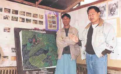
Royal Forest Department project officer and community organizer discuss the importance of three dimensional watershed maps to facilitate community land-use planning in Nam Sa
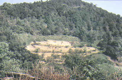
Formerly cultivated ridgetops in Nam Sa's upper watershed are now rapidly regenerating into dense evergreen forest while hill shift to terraced, more permanent fields below.
Swiddening hill tribes in the Nam Sa highlands are in the process of shifting their ridgetop fields to terraced, irrigated lands on midslopes and in the river valleys.
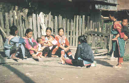
Intimately involvement in agriculture and forest products collection, Lisu tribal women in Nam Sa actively participate in Muban Committee meetings on forest protection and management.
In the past, Uncle Chan cultivated opium in his swidden plots, as well as upland rice, com, cassava, and other food crops for family consumption. While he could harvest over three kilograms of opium per rai, making it by far the most profitable crop, his increasing awareness of the liability of his own addiction and the fact that he was poisoning others finally led him to stop cultivating the crop. Influenced by the messages of RFD officers and community organizers, three years ago Chan decided to cease farming his upland swidden plots and to begin practicing more intensive agriculture near his home. Tapping his years of experience with mixed polyculture production, he now grows over seventy vegetable, herb, and fruit species in his three-rai homegarden. His staple foodcrops include rice, cassava, maize, and sweet potatoes; in addition, he grows eggplant, squash, beans, chilis, and mixed greens. He also cultivates his own coffee, tea, and spices -- including key ingredients in Thai cooking such as lemon grass and basil -- and underplants bamboo and rattan shoots in the surrounding natural forest. Huge papayas hang from Chan's trees, along with bananas, guavas, pomellos, lemons, apricots, and a variety of fruits unknown outside of Thailand.
To provide cash income, Chan's family raises silkworms on mulberry plants intercropped between the rainfed rice. Chan uses the stalks to mulch his soil and grows pigeon peas to fix nitrogen and enrich the soils with organic matter. Based on his success, Uncle Chan has become a demonstration farmer and key spokesman in the village for the transition away from highland swidden plots of opium and cabbage. Before the Network forum and Muban Committees were formed, Chan recalls that forest use in the subwatershed was out of control. Villagers were competing for land, communication channels were poor, and conflicts between upland and downstream communities were frequent. Chan has assumed an important leadership role in raising his neighbors' awareness of the interrelated problems and ecological linkages among deforestation, soil erosion, hydrological stability, crop productivity, and pesticide contamination. He has developed his own organic biocide spray, made from a concoction of tobacco, neem leaves, ginger, lemon grass, and soap and has become an outspoken campaigner against the use of chemical pesticides. Chan believes that pesticides have killed most of the stream fish and caused ill health in the community.
Uncle Chan's hilltop homegarden is surrounded by lush, regenerating evergreen forests-land in swidden not long ago. He recalls that the grove of dipterocarp trees towering in the distance used to be his grandfather's swidden plots. From the forest surrounding his farm, Uncle Chan collects more than twenty types of medicinal plants, which he and his wife use to treat family illnesses. They also gather a variety of mushrooms, fruits, and other forest foods to enrich their diet. Closer by, where dry rice had grown only five years ago, bamboo and coppice shoots from tropical hardwood species stand over ten meters high. Chan explains that the Karen tend to grow food in a particular field for only one year, leaving the big trees and smaller coppice stumps when they clear the plot. Through this management strategy to enhance natural regeneration potential, the forest rejuvenates quickly, often growing up to three meters a year.
At each Network meeting, Chan reminds his village neighbors that they can feed themselves and sustain a good life if they practice the conservation and wise use of the watershed's natural resources. He notes that at first the Hmong and Lisu resisted the idea of changing their practices of extensive upland shifting cultivation. But over time, as they visited Chan's farm to listen and learn, many have come to understand the need to practice settled agriculture given the growing population pressures and ecological sensitivity of the uplands. The power of farmer-to-farmer extension and demonstration in affecting change has been remarkable. Recently, Uncle Chan was honored by an unexpected invitation to speak to villagers from an adjacent subwatershed who have heard of his commitment and progress in Nam Sa.
The Lisu village in Nam Sa subwatershed was established thirty-six years ago by tribals who migrated from northern Chiang Rai and Tak provinces. Until two years ago, most of the forty families in the village derived the bulk of their income from opium cultivation. Consistent contact with community organizers and Muban Committee members in the Network gradually convinced the Lisu to stop growing opium and shift to plantations of mixed fruit trees in their upper fields. The Lisu community now holds regular committee meetings to discuss resource-use issues and management strategies. To ensure participation, each household is required to send at least one member over fifteen years of age to attend the meetings. Failure to do so results in a 100 baht ($4) fine for elected committee members and a 50 baht ($2) fine for other households in the community.
Typically located above the community, the spirit forest, or apamu, in a Lisu village functions as a sacred grove. The village shaman identifies a tree near the top of a ridge where the spirit resides, and the community builds a shrine to make regular offerings. The spirit forest has historically functioned as an inviolable source for food and medicine. The Muban Committee has designated 1,000 rai in the upper watershed as strictly protected forest, substantially extending the 50-rai domain of the original spirit forest. It has placed a ban on tree-cutting in the entire protected area, much of which is regenerated evergreen forest. Even more effective than the ban as a deterrent is the traditional belief that the forest spirit will create problems for those who disturb its habitat. A village story is told about a man who cut a tree in the apamu and lost his ability to walk until he offered a pig's head to the spirit. The committee is considering a new rule that offenders must take a vow before the spirit, swearing to no further transgressions. In addition to their protected spirit forest, the Lisu have designated an additional 400 rai of forest for fuelwood supply. Committee members have subdivided this area into eight compartments, to be used on a rotational basis for the collection of dead and dry timber. The fine for cutting green trees in the fuelwood forest is 500 baht.
With financial and technical assistance from the program, the Lisu have begun to construct terraced rice fields along the streams further down the valley. Initially, the project had requested the communities in the upper reaches of the subwatershed to shift both their villages and their fields to lowerareas. Lisu and Hmong communities were reluctant to move, and new settlement locations for villages were difficult to find. A compromise agreement was reached with the Lisu, so that only upland fields would be shifted. While this means a longer walk to lowland fields, the Lisu feel it is preferable to resettling their homes. With the use of communal labor, 10-15 days are generally required to clear and terrace one rai of paddy field, including the construction of diversion dams and irrigation canals. To facilitate water management, several Hmong and Lisu communities are also forming water user associations (muang fi). Through the collection of fines, as well as funds allocated by the UN Fund for Drug Control, the Lisus' village development fund currently contains an impressive balance of 11,000 baht ($458).
Spurred by a number of forces, the forest resource management initiatives by communities in the Nam Sa subwatershed have accelerated over the past few years. Members of the Karen tribe were increasingly distressed about the negative impact of upstream deforestation resulting from Hmong and Lisu clearance practices of ridgetops and steep slopes. Deforestation in the upper watershed was threatening the Karens' agricultural systems in the valleys and generating conflict among hill tribe communities that were failing to communicate with each other. Simultaneously, the Hmong, Lisu, and Karen had all grown concerned that the government might try to resettle them completely outside the subwatershed. The official policy to restrict habitation in certain reserve forest watersheds and the implementation of the controversial Khor Jhor Khor resettlement program posed serious threats to the villagers' tenure security. By cooperating with the RFD and other agencies, the communities may have felt they could evolve effective co-management strategies which could reduce the possibility of their resettlement out of the area.
Since Nam Sa was opened up seven years ago, villagers have also been subjected to increasing pressure to abandon opium cultivation. Project officers today report that opium fields have declined from 800 to 150 hectares in the entire watershed project area (
FN 12). The community organizers from the project were initially instrumental in helping villagers construct maps, understand watershed linkages, organize committees, establish a Network forum, and cooperate with each other in identifying strategies to deal with outside pressures and threats. By now, most of the Muban Committees in Nam Sa have become self-reliant, actively pursuing solutions to their management problems with minimal outside intervention. The program is beginning to multiply as Nam Sa's Network leaders such as Uncle Chan are invited to share their experiences with subwatershed councils in neighboring areas. Many of the sixty villages in the Pai watershed are now following Nam Sa's model, establishing Land-Use Committees and management systems with explicit rights, rules, regulations, and responsibilities.The Nam Sa experience holds promise that if encouraged and empowered, local communities in northern Thailand can successfully establish decentralized controls over resource use and begin to reverse the process of deforestation and environmental decline. In many cases, controls over burning, logging, and upland forest conversion to swidden have resulted in rapid regeneration of the natural forest ecosystem. While attempting to respond to the diverse needs of the traditional communities of the region, the program's Network of locally derived community institutions provides the operational access controls which have stabilized forest resource use. The village committees have joined the RFD as allies and partners in ensuring the protection and regeneration of natural forests in the upland watershed.
The hill tribes of the Sam Mun mountains are an intrinsic component of a dynamic watershed system. In contrast to the conventional resettlement approach which dislocates communities and would leave the watershed unpopulated, unprotected, and vulnerable to disturbance from outside forces, the Nam Sa project approach -- while requiring compromise and consensus from all parties -- has been able to respond effectively to both environmental goals and community needs. Ultimately, the question of insecure land tenure remains an open-ended, unresolved threat to the tribal communities of Nam Sa and beyond. The current land-use permit program will be unable to address the tenurial needs of the hill tribes, which lack Thai citizenship. It is hoped that as the documentation and dissemination of learning from inspired, grass-roots community initiatives spreads, a supportive national policy will be issued in Thailand to legitimize such management partnerships between the RFD and forest-dependent community groups such as those in Nam Sa. Only then will motivated rural communities across the Kingdom's northern watersheds have a chance to re-establish controls and share in the stewardship and benefits of their forest homelands.