Vo Tri Chung |
Nguyen Huy Dzung |
Eric Crystal |
Vu Van Dzung |
Mark Poffenberger |
Nguyen Huy Phon |
Peter Walpole |
|
Over the past 30 years the communities of the Da River watershed have come into contact with the outside world. By the mid-1960�s, after centuries of relative isolation from lowland governments, the ethnic minority communities of the Northwest uplands were connected to the outside world by an improving network of roads. During this period, the Northwest was also targeted for government programs and national policies were actively implemented and new socialist governance structures established.
In the past, land, water, and forest resources were managed through indigenous institutions, but increasingly their resource management systems are shaped by government policies. Expanding government resources have allowed the initiation of large-scale development projects and social programs to implement national policies in once remote upland regions. This report provides a brief description of the experiences of the communities in Chieng Hac commune as they attempt to balance their traditional cultures with a commercializing economy and the growing presence of government policies and programs.
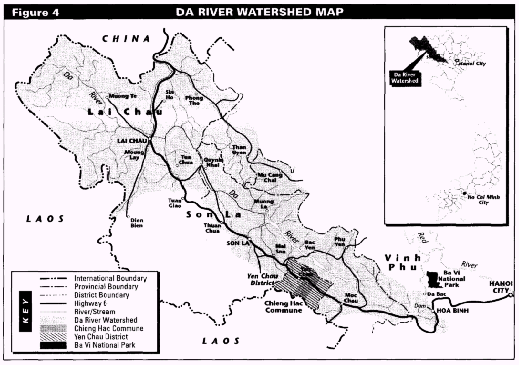
The Da River watershed is one of Vietnam�s poorest and least developed regions (see Figure 4). Many highland people are now confronting growing population and environmental problems, national and world market forces, and increasing government presence in their lives. Government attempts to meet basic food needs, economic development targets, and educational goals confront vast cultural and agroconomic diversity present in the mountainous Da River drainage. The Da River (Song Da) watershed is located in the northwestern corner of Vietnam bordering Laos and China. The topography is mountainous and strongly dissected, with an average elevation of over 500 meters and a maximum of nearly 3,200 meters. One million people presently inhabit the watershed, up from 320,000 in 1945, with a corresponding increase in population density from 12 to 37 persons per square kilometer over the past 40 years. Present growth rates are projected to enlarge the watershed�s population to 1.24 million in 1999 and to 2 million in 2019, reflecting a population density of 75 per square kilometer (FN 1).
Due to the mountainous topography of the Da River watershed, only 6 percent is designated for agricultural production, with less than 2 percent high productivity irrigated rice fields. Although the region�s total land area is 2.6 million hectares, 86 percent of the Da River watershed is legally classified as forest, but only 10 percent possesses good forest cover. Much of this shrub-and grass-covered, "barren" land is used by shifting cultivators. The region was probably well-forested several hundred years ago, but has experienced extensive forest loss that has accelerated in recent decades. Denudation appears to have resulted from successive waves of ethnic communities migrating from southern China, relying on fire to clear lands for agriculture and grazing, combined with more recent pressures from commercial logging and lowland migrants (FN 2).
The fundamental issue in Son La province and other parts of upland Vietnam is how indigenous cultural systems are adapting to broader sociopolitical and economic trends emanating from lowland Vietnam, and how new government policies and programs are supporting ongoing transitions. The region�s cultural communities remain distinctive, with continuing reliance on traditional leaders and institutions, and on human-ecological practices adapted to the Da River watershed. At the same time, local government officials and structures have increasing influence on the lives of ethnic minorities, while growing market access and privatization has stimulated trends towards commercialization of the local economy. Government policies and programs have also had a marked impact in the area. Policies enforced over the past 5 years banning the opening of new swidden fields and the cultivation of opium have affected the land use practices of many Tai and Hmong households living in the Song Da. New land allocation programs have also brought government further into resource use practices. The new forest land allocation policy encourages the commoditization of land resources, a supportive action for those households ready to invest in commercial crop production, but inappropriate for upper watersheds traditionally held under communal forms of management. Sedentarization, land tenure, intensification, and the management of remaining forests are all important issues in the Vietnamese uplands.
The allocation of forest land to households is now being attempted on both sides of Highway 6 in the Da River watershed. Replicating this effort in more remote parts of the watershed presents major problems. The reallocation process, while participatory in its design, reflects a local government, committee-driven process that gives little emphasis to the integration of the traditional resource management systems of the diverse ethnic minority groups present.
The Tai. The Da River watershed possesses 23 ethnic groups. The Tai are the most populous ethnic group, with over 410,000 people, followed by Kinh and Hmong, each representing 18 percent of the region�s population. The Tai are believed to have migrated into northwest Vietnam from southwest China 700 to 800 years ago. Tai farmers sought out reliable water sources and valley bottoms to establish wet rice fields and fish ponds, growing other crops and establishing orchards on the lower slopes. In Son La Province, over 70 percent of the population is Tai. Tai communities are organized around chau, river valleys which historically comprised politico-territorial units. So great was the concentration of Tai in Northwestern Vietnam/Northeastern Laos that in recent centuries they formed a political confederation termed the Sip Song Chau Tai (Twelve Tai State Confederation). The Tai presence in the Yen Chau administrative center (Huyen or district headquarters) is immediately striking. Many district officials are of Tai descent including the woman who heads the district people�s committee and the woman who manages the local guest house.
Fundamentally oriented towards irrigated rice cultivation, the Tai have been concerned with water resource management, irrigation channel maintenance, rotation of hillside crops, and have planted grasses and trees for centuries. Tai houses are typically large, raised on stilts with wide porches upon which much food preparation and textile design is undertaken. This has been a traditionally stratified society. Wealth is manifest not only in the size of the house, but also with the number of boxes or trunks holding textiles, jewelry, and other valuables, which are arrayed about the living area, and also by the number of fa or fold-out mattresses stored in the attic above the ground floor.
The Kinh. As members of Vietnam�s dominant lowland majority, most Kinh have moved into the area during the past twenty years. Kinh population in the Da River watershed is concentrated near the provincial capitals of Son La and Lai Chau and around provincial agricultural and forestry enterprises. The New Economic Zone policy of the 1960�s, and other programs, have encouraged Kinh migration from the densely populated Red River Delta. The population of Kinh people in the upland regions of Northern Vietnam grew from 640,000 in 1960 to 2,560,00 in 1989, a four-fold increase placing immense pressure on natural resources (FN 3). Many Kinh came to work on State Forest Enterprises, clearing large tracts of timber. Frequently, public companies experienced management problems driving Kinh migrant workers to run their own logging operations and clear additional forest land to establish farms. It is estimated that up to 75 percent of the deforestation occurring over the past three decades has resulted from SFE, collective logging operations, and migrant land clearing.
The Hmong. The Hmong are believed to have begun immigrating into the Da area approximately 200 years ago. Movement of Hmong from isolated regions of southern China into the uplands of northwestern Vietnam and across the border with Laos continues today. The 170,000 Hmong of the Da River watershed population are concentrated in upper mountains and plateaus. They practice shifting cultivation on hill slopes for varying durations, planting such staples as dry rice and corn, while growing opium poppies in the winter for sale or barter. The productive potential of the soil and water resources of upland Hmong communities is generally much less than that of the valley dwelling Tais. To maintain the productivity of their farms, Hmong will shift their fields and their settlements periodically. One study of 170 Hmong villages in Bac Ha district in the Da River watershed found 62 percent of the villages moved between 1974 and 1989.
Nguyen Van Thang, a Vietnamese anthropologist, explains, "Within the uplands of northern Vietnam, the Hmong people tended to move northeastward...from highland to lowlands, around the base of mountains that were not occupied by other ethnic groups, practicing swidden agriculture." Thang continues, "Recently, due to the Vietnamese government�s policy banning opium poppy cultivation and reduction in the forest area available for making swidden, Hmong people have begun moving into the remotest forests " (FN 4). He concludes that Hmong existence is precarious at present, with some communities fleeing into the forests of Laos and others being forced into resettlement villages.
The Hmong, the Tai and some of the other semimigratory ethnic minority groups that practice subsistence swidden agriculture have been the de facto managers of much of the Da River�s upper watershed for well over 500 years. They have played an important role in transforming the vegetative cover of the landscape and even altering the microclimate. While the government has established policies and programs to halt shifting cultivation, it is not clear how far they can be implemented, or what viable alternatives will be available to swidden farmers.
Due to their isolation the Hmong have experienced difficulties in relating their village economies with the expanding lowland market that is penetrating the region, not to mention accessing health care and educational services offered predominantly along major roads. The 1993 government policy to destroy all poppy fields, while not entirely successful, has greatly reduced income from the group�s only major cash crop. Project-based efforts to provide substitute crops such as fruit trees, sugar cane, and peanuts have had limited impact, due to their lower profitability and limitations of government capacity to deliver the necessary extension and market support (FN 5).
The Da River watershed has been profoundly changed by the construction of the Hoa Binh Dam between 1979 and 1994 at a cost of US$2 billion. The region was only connected to the lowlands in the 1960�s when the road was built to the Northwest in conjunction with preparations for the construction of the dam. The dam now supplies nearly 50 percent of Vietnam�s electricity, powering much of the urban, industrial development taking place in the lowland deltas. Damming the Da River resulted in the inundation of 200 square kilometers of surface area, extending 230 kilometers upstream. As a consequence, 58.000 people were relocated, largely Tai, Hmong, and other ethnic minorities who had resided there for generations.

The Hoa Binh Reservois extends 230 kilometers behind the massive Hoa Binh Dam, inundating 11,000 hectares of farmland including 4,000 hectares of high productivity irrigated rice that once was the fertile Da River Valley. The reservoir displaced 58,000 people, many oof whom resettled on the upper slopes of the watershed, farming marginal and eroding soil. (photo: Poffenberger)
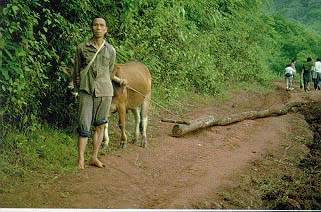
Hmong man of Chieng Hac Commune uses his cow to haul a log from the forest. Upland families displaced by the Hoa Binh project are even more heavily dependent on upper watershed forest resources since their lower elevation fields were flooded. (photo: Poffenberger)
After losing their wet rice padis and dry fields, displaced families are forced to clear an additional 2,000 hectares of forest annually, placing additional pressure on the watershed. Erosion levels have increased to such a degree that engineers have been forced to reduce the projected life of the dam from 300 years to 50 years due to heavy sediment loads filling the reservoir. A second dam is being planned upriver from Hoa Binh at Ta Bu near the provincial capital Son La. If constructed, an additional 130,000 people could be displaced and much of the remaining irrigated padi land in Son La and Lai Chau provinces would be inundated, creating even greater pressures on the upper watershed. While the second dam is attractive to some foreign investment firms and could provide much of the power needed for further economic growth in the delta over the next 35 to 50 years, it would create immense displacement for the people and economy of the Da River.
Son La is one of three provinces which comprise northwest Vietnam, and together with Lai Chau province, controls most of the land in the Da River watershed. Three quarters of the provincial population are Tai, with Kinh residing in the provincial and district centers, and the Hmong scattered through the higher mountains. The provincial government is responsible for assigning district heads and formulating development plans for the district and communes based on central government policies, programs, and budget allocations. Since the national economic liberalization was initiated in 1986, district and commune level officials are allowed to review and evaluate the plans before they are finalized.
The Yen Chau district has thirteen communes and one town, with most communes consisting of 10 to 20 scattered settlements, each possessing 10 to 100 families. Yen Chau�s total population is 49,000. The centers of economic prosperity are located in the town and eight larger villages along the Sap and Vat rivers, where much of the district�s 8,000 hectares of rice land and fish ponds are located. Tai people tend to dominate the river valley communities, with Hmong, Xing Mul, and other ethnic minority groups living in villages along the tributaries and in small highland valleys and hillsides. The Tai are more dependent on irrigated agriculture, fish farming, and animal husbandry, but also practice long rotation cassava farming on unterraced hillsides neighboring their communities. The higher elevation ethnic minorities often possess little or no wet rice land, concentrating their agricultural activities on three distinctive forest-based swidden systems; maize, dry rice, and opium. The chief of the district (huyen) is a local Tai who holds a two-year term and works with a council of 20 to 40 members. District government responsibilities include tax collection, property assessment, monitoring development activities, and carrying out basic administrative functions.
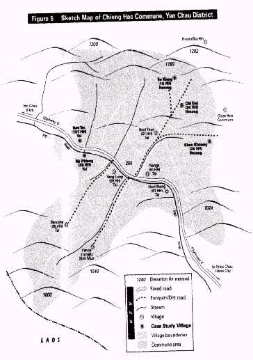
Chieng Hac commune is located approximately 6 kilometers to the south of Yen Chau town, on the road to Hanoi (see Figure 5). The commune has 3,400 people living in 11 culturally distinct villages. Eighty-one percent are Tai, 16 percent Hmong, and 3 percent Xing Mul. Divided by the Sap River, which is paralleled by Highway 6, the commune stretches 5 kilometers to the north and 7 kilometers to the south, sharing its border with neighboring Laos. Of the commune�s total area of 8,700 hectares, almost half is upland fields. Another 40 percent is old growth and secondary forest or bamboo groves, and only 12 hectares are irrigated rice land.
The commune is governed by a council representing the resident population. Each member on the council is appointed for a 2-year term. There are quarterly meetings to discuss the implementation of the commune 5-year plan. Commune members undergo short training programs on national laws and policies at the district level.
Ban Tat village was established approximately 100 years ago, although the ancestors of most residents have lived in Yen Chau district for at least 300 years. Before 1954, the entire area was largely covered by old growth evergreen forest, with only seven families inhabiting the village. The original settlers depended primarily on irrigated rice cultivation, home gardening, and fish raising. By 1975, the village population grew to 76 families, and today there are 101 households in the community. Expanding the irrigated rice area was not possible due to water shortages. The growth of the village required much of the surrounding forest land to be cleared for cassava and corn fields. In recent years, village households have gone farther into the uplands to open forests for additional dryland fields, traveling up to 7 kilometers from the community, which is located at 250 meters on the banks of the Sap River, up to elevations of 700 to 900 meters.
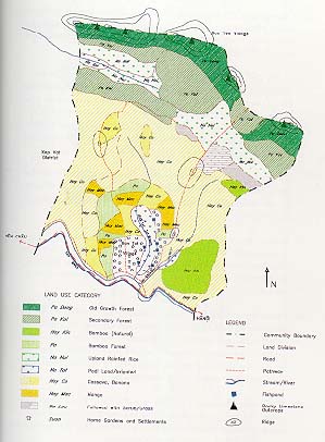
In the local Tai dialect, Ban Tat means "the village with narrow padi fields," reflecting the difficulties farmers have experienced in creating fields for irrigated rice. Of Ban Tat�s 1,342 hectares, only 7 hectares are irrigated fields. 700 hectares are natural forest, with most of the remainder dryland fields under a long rotating fallow and cultivation cycle. In the map of Ban Tat, shown in Figure 6, the extensive tracts of old growth (Pa Dong) and secondary forest (Pa Kai) are visible, with the extensive casava fields (Hay Co) in the lower slopes above the village. As a result, most households in the community are heavily dependent on the cultivation of cassava and corn on the sloping land above the village, supplemented by cattle raising, small orchards, and fish ponds.
The community lives in long, raised wooden houses where two to four nuclear families reside. Most houses are clustered just above the road. The buildings are situated in large compounds with fruit trees and vegetable gardens in small bamboo fenced enclosures. Most house yards possess a fish pond with the animal pen situated on the side. Home gardens, aquaculture, and animal husbandry systems exchange nutrients efficiently and are highly productive sources of protein and vitamins, as well as important for generating cash.
The local Tai resource-use system recognizes many categories of land use (see Figure 7).
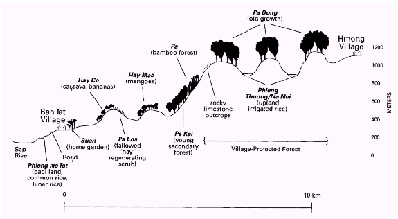
These include:
1) A: Lowland Irrigated Rice (Phieng Na Tat): Phieng means "flat or open place," and Na refers to "padi field." Most phieng are level terraces formed in valley bottoms at 250 to 300 meters. Phieng often have fish ponds attached above or below the padi fields. Due to their productivity, phieng are highly valued. Community organizations mobilize labor for maintaining irrigation systems. The water requirements of phieng and fish ponds are a major incentive for protecting upland forests and watersheds.
B: Rainfed Rice (Phieng Thuong and Phieng Na Noi): These small rainfed fields are located in upland valleys at elevations ranging from 900 to 1,100 meters. They tend to cover smaller areas, rarely more than 1 to 2 hectares in size. Due to their higher elevation and lack of irrigation, they tend to be less productive than Phieng Na Tat.
2) Grazing Land (Phieng Quai). Fallowed dry rice and cassava lands, which when fallowed are used for grazing water buffalo. During the rainy season they revert to use as rainfed padi fields (Phieng Thuong) or dlyland fields (Hay Co).
3) A: Dry Upland Fields (Hay Co). Hay Co is largely used for the cultivation of cassava for domestic and limited market production. Fields normally range in size from 0.5 to 2 hectares and are situated on steep slopes of� 20 to 40 degrees and at elevations up to 600 meters. The cassava crop is normally left for two years to reduce soil disturbance. Maize is also grown as a secondary crop, along with some legumes. Bananas are planted on the edge of fields.
B: Dry Upland (Orchards (Hay Mac). Hay Mac is usually used for fruit trees, primarily mangoes. It is likely that these lands were once Hay Co which were planted with fruit trees after the annual cropping period was finished.
4) Bamboo Forest (Pa). Extensive bamboo forests are located from approximately 600 to 800 meters. In 1976, 15 hectares were planted (Dendrocalamus sericeus) by a group of 10 households. Bamboo poles are harvested and shoots are collected both for domestic needs and the market.
5) Fallow dryland fields (Pa Lou). Usually found on sloping land and covered with 1- to 10-year-old shrubs and saplings, this land is usually on a 2- to 5-year agricultural rotation. In some cases, if its nutrients were overly depleted because it was cropped too long or excessively burned, the land may become dominated by imperata grass. In better sites, young secondary forest may emerge.
6) Middle-aged forest of 10 to 20 years (Pa Kai). These forest types are usually located on abandoned upland fields that were not reopened due to fertility problems or lack of accessibility. They may be considered agricultural lands under a long fallow cycle.
7) Primary or old growth forest (Pa Dong). These forests are often situated on ridges or hill tops. Tai communities protect Pa Dong from timber felling and field clearing in recognition of their hydrological importance. The Tai of Ban Tat understands need to conserve the upper watershed to ensure reliable water flows from springs to downstream rice fields and fish ponds. In many cases, these forests are also located on steep limestone bluffs where farming is impractical. Some Pa Dong are believed to be the home of spirits and ancestors.
Ban Tat village has a traditional system of forest protection under the leadership of older men known as Xompa, meaning "forest protector." The Xompa was responsible for overseeing forest use including 1) ensuring the strict protection of upper watershed forests; 2) designating production forests and allocating selective cutting rights for housing and tools; and 3) mobilizing the community to control forest fires. The Xompa system appears to have fallen out of use in recent decades as the authority of the commune has been extended over forest resources.
In an interview with the research team, Mr. Lo Van Beo, the headman of Ban Tat said, "We need more Xompa. The last Xompa was Mr. Quang Van Hien, born in 1904, and since he died we have had no new Xompa." "We feel Xompa is a very useful part of our Tai tradition. Many Tai villages in our area had Xompa, not just Ban Tat. Now outsiders have come and the populations have grown." Mr. Beo noted that before 1992, each village made their own forest use rules. He suggested that a new Xompa be chosen and that each household should assign one member for forest protection and management activities. Mr. Lo Van Lai, one of the oldest men in Ban Tat, echoed the headman�s sentiments when he said, "Most importantly, we must value highly forest protection and our village needs to promote this. We need to focus on the benefits of forest protection to local people. We need to reorganize the Xompa system with the support of the commune. As a second measure, we need to identify on a simple map, forests in need of protection and those we could use."
The Xompa of Na PhiengLo Van Haum was born to a Tai family in 1914. In 1945, Lo�s family and two other Tai households left homes in a nearby village along the Sap River and cleared the dense forests to establish Na Phieng village. At that time most of the surrounding land was forested, with tigers, wild pig, deer, and elephants inhabiting or passing through the area. The site for the new settlement was chosen by the old Xompa in the young families� origin village. Lo was appointed Xompa for the new community due to his knowledge of traditional agriculture. As Xompa, which literately translates "protector" of "forest," Lo was responsible for ensuring land, water, and forest resources of the community were sustainably managed. Lo worked with household heads identifying upper watershed forest (Pa Dong) that would be closed to agriculture in order to prevent erosion or a disruption water flows serving irrigate rice lands and fishponds by the village. The Xompa also guided decisions concerning the location and length of rotation of upland fields, planting and felling of bamboo and timber, and the placement of forest fruit gardens. In addition, Lo, advised farmers in swidden clearing, burning, and planting decisions. During the 1970�s, when the government required Na Phieng to communalize land management, the Xompa system was displaced by committee structures. Today, Na Phieng has grown to 32 households, and as the village expanded forests were cleared for agriculture and aquaculture. To protect upper watershed household cash income, the community set aside 22 percent of the village land area as protected forest. Villagers report that since the mid-1980's, economic liberalization policies (Doi Moi) have allowed households to intensify fish production and mango orcharding. Much of the long rotation swidden land that and ensure water delivery to the fish ponds that generate a large part of regenerates as secondary forest and occupies 59 percent of the village territory is now being allocated for household forestry. Many Na Phieng families are uneasy with the terms of new government forest east programs, including recommended technologies. Some households feel the new government land allocation contracts actually undermine their tenure rights, since these same Pa Loa and Pa Kai lands had been allocated under the traditional Xompa system to village households in the past. Mr. Lo and other village leaders feel there is a need to reestablish the Xompa and related Tai resource management in institutions in order to reconnect local traditional and emerging land use practices with government programs. Local Tai acknowledge that there are also problems with forest fires started during agricultural burning or by careless hunters, and that indigenous forest protection groups could help protect their important watershed forests, and that the Xompa could strengthen community controls over resource use that are badly needed as use pressures increase. |
Village elders noted that the major threats to the forest came from the opening of new cassava fields in poor sites and from forest fires that escape when agricultural fields are burned to clean fields, or are set by hunters, or fires that are set by angry people who have not been allowed to open new fields. In the past, commercial grazing in the highland watershed also suppressed forest regeneration, though since that has stopped, grazing pressures are reduced to local use and this problem has been reduced. Because forest clearing for farming and burning occurs between October and April, this is the likely period when most attention needs to be given to forest protection, particularly in March and April. Community members have become better at controlling fire. Before 1982 there were usually 20 fires a year in the Chieng Hac commune. However, during the 1990�s the community has only averaged 10 fires which typically burned a total of 10 to 20 hectares.
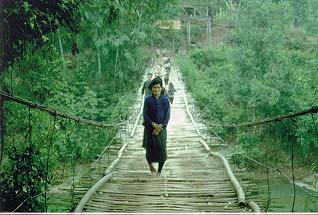
Bamboo suspension bridges like this connect the Tai Villages of Chieng Hac Commune that are located along the Sap River. Forest and upper watershed protection are gaining importance as commercial aquaculture, dependent on upland springs and rivers, has grown rapidly as a primary source of income for many households. (photo: Poffenberger)
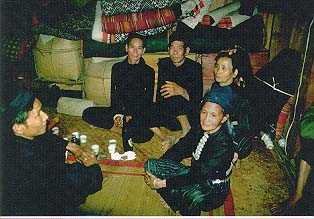
Tai elders in Ban Tat Village meet to celebrate the building of a new house constructed of timber from community forests. Traditional gatherings of this type provide opportunities to discuss resource management issues. The opinions of the elders remain influential, although new local government structures have formally supplanted them. (photo: Poffenberger)
According to Ban Tat elders, some community members are upset because they are not allowed to open new swidden fields. Ban Tat villagers reported that they want to gain greater tenure authority over their upland agricultural and forest lands. They are interested in protecting existing forest lands to ensure spring flow and water availability. Ban Tat elders feel the need to better determine which lands must be reserved for watershed conservation and which could be opened for agriculture. They are especially interested in ensuring the continuing availability of useful timber species.
In neighboring Sap Vat Commune, the 10 Tai villages protect over 1,000 hectares of forest that is a critical source of water for rice lands and fish ponds. Increasing concern for the forest decline has resulted in each village forming a 12-member committee. The immediate activities are: protection against burning, identification of areas for potential use and exploitation, division of forest area among the villages for protection, and issuing permits for forest exploitation. Forest management conflicts are settled by the commune representatives and the offending party(s) involved. Illegal burning or cutting may entail a fine of US$3 per square meter, for bamboo US$0.05 per shoot, and for timber US$2-5 per tree. In 1995, the commune was able to plant 29 hectares of teak in the uplands with seedlings provided by the Nai Yon Forest Enterprise, and 14 hectares of fruit trees (longan) with saplings from the Forestry Extension Unit.
The three Hmong communities of Chieng Hac Commune are located at the base of limestone bluffs at elevations of 850 to 1,000 meters (see Figure 8). The small upland valleys and plateaus the Hmong inhabit are perched behind a ridge, separating them from Ban Tat and the other Tai communities below, near the banks of the Sap river. The Hmong villages are located approximately 6-10 kilometers from Highway 6. The limestone bluffs are covered with dense, old growth evergreen forests. Below these dense forests are maize fields, dryland paddy, and communities towards the bottom of the highland valleys.
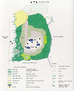
The original Hmong settlers of Chi Dai came from Lao Ki Tao in southern China 300 years ago. Chi Dai village currently has a population of 280 people residing in 34 households. Land shortages, both for houses and farming, have forced some Hmong families to move to nearby areas. In 1975, some families began moving to the neighboring Hmong community of Bo Kieng, and recently six families resettled in a new site near Chi Dai that now has 16 families.
Farther to the southwest, across a small limestone ridge, is Khao Khoang. The 28 families (147 inhabitants and 40 laborers) are situated in a scattered pattern above a small stream that runs the length of the valley. Several small springs are found midway up the valley walls. According to Mr. Vang Lau Zenh, the village headmen of Khao Khoang, up to the 1940�s elephants were still present in the area, while the last tigers were seen during the first part of the 1960�s. Bears searching for honey and other food occasionally move through the area, while red-faced monkeys are relatively abundant. A few families settled in Khao Khoang, which literally means "limestone spring." prior to 1954. By 1960, about six families moved from Chi Dai and a cooperative was established.
The Hmong farmers of Chi Dai are in the process of transition from traditional open cycle swidden cultivation, involving continuous clearing of new forest for fields, to more sedentary systems of agriculture. This change is driven by the expanding community population, the growing shortage of forest land that can be converted to agriculture, and government sedentarization policies. In an attempt to identify how the Hmong defined their current agricultural practices, the village headman, Mr. Van Lau Zenh, was asked to identify major land use systems of the Hmong community (see Figure 9). These included:
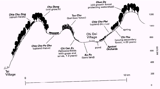
1) Upland Maize Fields (Chia Cho Po-Chu). Maize fields are usually sited on moderately steep, stony slopes. Crops are grown for 2 to 5 years depending on fertility and yields and are then fallowed for a minimum of two years. Field clearing is done during the months of February and March, after which the slash is left to dry for a month before burning. The fire is set at the lowest part of the field, downwind.
2) Upland Dry Rice (Chia Cho Plei). Dry rice is grown on more gradual slopes for two years followed by one year of maize. If yields continue to be good, an additional crop of rice may be grown before fallowing.
3) Ridge Top Opium Fields (Chia Cho Zing). Opium fields are situated in old growth secondary cloud forests in small patches. They require humid, high elevation sites above 900 meters, with black soils. Opium can generally be grown for one to three years before fallowing the fields.
4) Regenerating Fallowed Fields (Chi Can Zu) are typically covered by wild grass, shrubs, and some saplings. If fields have been overly depleted they may be invaded by grass (Imperata cylindrica). The land is usually opened again for agriculture after two to three years. When imperata has invaded the field, the grass is cut, burned, and then plowed with horses.
5) Young Regenerating Forests (Chi Phu). These forests are usually found in abandoned upland field sites and are reopened after five to seven years of regeneration.
6) Bamboo Forests (Hasong) may occur naturally or may be established plantation. Both are managed through thinning and harvesting with poles valued for construction purposes and shoots collected for food.
7) Old Growth Evergreen Forests (Chan De). Old growth forests which are protected for watershed conservation.
While in the past, most Hmong have practiced a pioneering form of shifting cultivation that tends to sharply deplete forest soil fertility, indigenous agricultural systems also reflect soil and water conservation values and techniques. Hmong normally attempt to site swidden fields on the lower portion of hills, protecting vegetative cover on the upper half of the slope. The planting of hedgerows and building up of field edges to prevent erosion, as well as contour plowing, were common practices, as was inter-planting with legumes to promote nitrogen fixation (FN 6). Hmong communities like Chi Dai are attempting to respond to growing land scarcities by using traditional knowledge and new technologies to feed their families on their marginal upland soils.
The Hmong families of Chieng Hac are poorer than the Tai households at lower elevations, and are primarily dependent on corn cultivation, supplemented by dry rice. Bananas and taro are planted on the upper sides of dryland fields. Squirrels and small birds are hunted in the forests, while chickens and pigs are raised in the settlement�s house yards. The villagers also collect medicinal plants and fuelwood from the forest. Some families also keep water buffalo, and many own one or two horses for transportation and plowing.
Cash income is generated from the collection of cinnamon bark from wild trees in the old growth forests. Cinnamon sells for VND2,500 (US$0.23) per kilogram in local markets, and men and children are still able to collect 30 to 40 kilograms in a single trip. A few Hmong farmers, including Mr. Zenh, are having some success with the cultivation of apricots in their house yards. In the last year, a fish pond has given satisfactory returns and others are now experimenting with fry bought in the town. Poor water supply and distance from markets are critical limitations that have yet to be addressed. Twenty years ago, a government-supported school offering classes through the third grade was established in Chi Dai, using Vietnamese as the medium of instruction. While two students from the village are now in the commune central school at Chieng Hac, most village children do not study beyond the third grade.
Since 1991, no opium has been grown in Khao Khoang and no new fields have been opened in the high cloud forest above the village. The opium ban has had a drastic effect on the incomes of local villagers. According to local informants, one hectare of opium when harvested in January could yield as much as 5 kg of opium. Itinerant traders in former days paid as much as VND800,000 -1 million (US$73-$91) per kilogram of opium.
In the wake of the government ban, efforts were undertaken to transform Hmong agriculture. Apricot tree seedlings were planted on the ground of a model farm, one which also included a fishpond and some very small irrigated rice fields. The fishpond concept, not traditional for Hmong villagers in this area, has been imitated by a number of villagers. Apricot trees, which seem particularly well adapted to lands formerly planted to poppy, have thrived and two harvests have already been taken in.
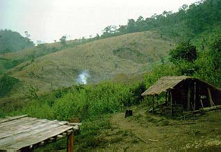
Population growth and government prohibitions on forest clearing to open new fields has disrupted traditional Hmong long rotation swidden farming practises. Whether these erodible, low fertility slopes can sustain sedentary farming remains to be seem with farmers now reporting declining yields (photo: Poffenberger)
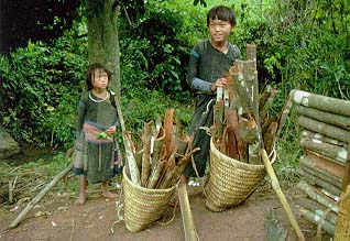
Hmong children return from a Cinnamon bark (Cinamomun cassia) collecting trip in an old growth forest. An adult can collect 30 to 40 kilograms in tree to four days for VND 2,500 (US$0.23) per kg, making it an important source of cash income for local households. (photo: Poffenberger)
During the dry season in Khao Khoang (November-March), large Zil trucks sometimes make their way on a very rough dirt track which leads past Khao Khoang and then descends to Black Tai settlements along the banks of the Da River. These trucks collect Hmong corn for sale in the Yen Chau market in October and apricots in March. Informants report that cash yields per hectare on nascent apricot harvests are about 10 percent of what they would have been on poppy harvests. Clearly the household income loss has not been replaced, even for those few households who have successfully obtained and nurtured fruit tree seedlings.
Agricultural production and household incomes have been greatly altered in Khao Khoang as a result of the opium planting ban. The total swidden area is only 20 hectares, and with bans on the opening of new fields, nutrient levels on existing farmland are said to be declining with a corresponding fall in crop yields. Corn comprises about 80 percent of all food produced, supplemented by bamboo shoots and fruit.
The community possesses 130 cattle, 20 buffaloes and 40 goats that graze freely around the village, along with about 10 pigs per household. Cattle are important because they can be sold during the famine months from April to June. About 30 percent of the families experience food supply shortages and malnutrition is evident in the village. At present, without income from the opium crop, many Hmong households have insufficient funds to purchase food to feed themselves during the famine season. Policies and programs that do not address this core problem will not receive support from the Hmong communities in Chieng Hac.
The village headman of Khao Khoang, Mr. Zenh, reported that given growing population pressures, while there had not been a traditional system of forest management among the Hmong, the Hmong are gradually intensifying forest protection activities among themselves and in coordination with neighboring villages. In the 1970�s, Hmong communities began placing tighter controls on field burning by requiring farmers to cut a fireline above the fields and positioning a person in the break to prevent the fire from escaping up-slope. Delineation of the political boundary of Hmong land was done in 1994, apparently as part of the forest land allocation program.
The village agrees with the boundary demarcation, but they are still uncertain what the government wants in terms of managing barren land. While they support land rehabilitation, they are especially interested in commercial plantation activities. They want to plant apricot while the land has some fertility, but lack the money for investment in seedlings. Chi Dai villagers reported that district officials have never visited their distant settlement to discuss ways to intensify farming practices and generate cash.
In 1995, Mr. Zenh, who knew the Xompa in a neighboring Tai community, began establishing a forest protection committee for the Hmong community and sought formal recognition from the commune. Khao Khoang is situated directly adjacent to a large protection forest, and hunting and gathering continues to constitute a major village enterprise. Medicinal plants are gathered in the forest, but the availability of other resources is declining. The village leader has informed the community that the forest is protected, violations will be punished, and three groups have been established to monitor the area.
Forest protection efforts have helped to reduce exploitation of the forest. In protection forest, only dead wood can be collected. A few years ago, a farmer was fined VND15,000 (US$1.36) for cutting bamboo. The community has also attempted to control hunting. In one case, the villagers tried to restrain outside hunters from killing a bear which lived on the mountain above the village. According to Mr. Zenh, the hunters succeeded in killing the bear because the community lacked the authority to stop the outsiders. He said that the commune needed to give the Hmong hamlets greater responsibility for protection. He felt once they had reached an agreement regarding forest use regulations with their neighboring villages the commune should recognize the new protection system.
Mr. Zenh believes protection can be done on a volunteer basis and that effective access controls can lead to natural regeneration. Mr. Zenh is concerned, however, that without support and incentives from the commune, it will be difficult to sustain the group. He has proposed that some commune tax revenues from dryland farming, padi, and fish ponds be used to help finance the Hmong communities� forest protection activities. Mr. Zenh is also negotiating with one downstream Tai community to explore possible compensation for Hmong forest protection efforts and the assurance that needed water will be delivered.
Mutually supportive resource management agreements between ethnic groups practicing different land use systems within the same watershed will be necessary to minimize future conflicts. Government policies and programs should be designed to facilitate local dialogue and generate agreements between user communities. By examining the process through which agreements are made between communities in areas like Chieng Hac, planners can identify critical needs and issues, as well as frameworks for cooperation in actual contexts.
Prior to the construction of National Highway 6, rural resource management in the Da River watershed was carried out by village-based social institutions characterized by the cultural traditions and agroecological practices of each respective ethnic group. While precolonial states and the French colonial rulers periodically exacted taxes or tribute, operational management was largely maintained under customary law. Day-to-day decisions on land, water, and forest resource allocation were handled by leaders and councils within each settlement, with major decisions or disputes referred to multihamlet federations or local chieftains. While the northwest was often viewed as a wild, uninhabited region by Kinh lowland officials and foreigners, much of the region and its boundaries were "elaborately defined by these communities, with some lands available for cultivation and others for preservation of forests...despite the appearance of wide-open frontiers, even the migratory Hmong were not able to settle anywhere they chose but had to find unclaimed lands, or, if there were claims on lands, negotiate use rights (FN 7).
During the 1950�s and the 1960�s, the national government encouraged villages to formulate cooperatives, though the membership of the cooperatives and decision-making processes may have continued to reflect traditional modes of operation. By the 1960�s and 1970�s, the government tried to establish multivillage cooperative units or communes. However, the 1980�s brought policies that shifted away from collectivization, returning authority to the village, and, most recently, to households. Some specialists speculate that indigenous villages may regain greater autonomy, creating opportunities for traditional institutions to reestablish their role in resource-use decision making (FN 8). Yet government policies and programs, while de-emphasizing collectives, give little recognition to the role of the traditional villages. Instead, these new policies and programs stress empowering the household or individual.
Many central government programs have had mixed or limited impact in the Da River watershed. The Fixed Cultivation and Sedentarization program, initiated in 1968, attempted to stop the practice of shifting agriculture. After nearly 30 years, it is estimated that fewer than half of the country�s two million swidden farmers were resettled and many continue practicing shifting cultivation, in part due to the absence of viable alternatives. Decree 327, which was issued in 1992, built on the earlier Fixed Cultivation program targeting the restoration of barren hills with industrial crops where possible. Under these programs, forest lands have been broadly divided into three categories:
1) Land suitable for dryland agriculture on a rotation allowing for a three-to five-year fallow, which tend to remain under shrub vegetation in an early phase of regeneration.
2) Less fertile forests on steeper slopes which are in a much longer rotation and have been regenerating into dense bamboo stands or young secondary forests.
3) Old growth evergreen forests located on ridge and hill tops which are often protected by the village for hydrological reasons, yet exploited for produce like firewood.
The issuing of a new policy requiring the allocation of forest lands to commune households provides new opportunities for decentralizing management. The new policy was formulated to tighten forest-use controls by vesting rights and responsibilities locally, and as part of the broader national attempt to privatize production systems. The policy does appear to address the broader needs for upper watershed protection. The reallocation program appears to be best fitted to secure tenure rights for households on Type 1, and possibly Type 2, forest described above. The Type 3 upland forests, not under long rotational agriculture because of their physical features and hydrological importance, may best be managed by community institutions. However, this possibility is not yet supported by specific community forestry management policies.
The sustainability of natural resource-based production systems in the Da River is threatened by multiple factors. Growing local populations place additional pressures on marginally productive lands. Many farmers are experimenting with modified cropping systems while traditional communities develop stricter resource-use controls. While the villages of the watershed retain their strong traditional cultures, each dependent on their own land-use practices and informal authority structures, the communities of the Da are increasingly engaging in contemporary market economies.
Government programs assume that upland communities are ready to shift their production systems to individual or household-based business ventures and provide little support to earlier resource management strategies. Policies that stress privatization and commercial development, without reference to traditional social institutions that have overseen resource use in the past, may undermine community capacity to regulate human interaction with the watershed in the future. Even more threatening to communities in the Da River area is the likelihood that local resource requirements will be sacrificed to meet the power and raw material needs of the lowland population. In order to understand community resource management behavior and emerging concerns over government policies and programs, diagnostic studies were carried out by the research team among the Tai and Hmong villages of Chieng Hac Commune.
Upper watershed forest protection has long been recognized as a necessary part of community resource management systems in Yen Chau. While expanding populations have put increased pressure on forest resources for conversion to agriculture. local institutions have continued to set aside upper slopes and hill tops, excluding them from timber felling and farming. National government programs and regulations that ban shifting cultivation and encourage forest protection rarely build on local resource management strategy. Rather they rely on entirely different set of incentives and formal legal codes to leverage community cooperation.
Provincial, district, and commune governments have implemented new policies in ways that minimize conflicts and respond to local conditions. However, outside policies that are unsupportive of indigenous systems of resource management and governance inevitably fail to work with the positive components of ethnic minority cultural values and social systems, and may not respond to their most urgent problems and concerns. By ignoring their presence, top-down programs erode the legitimacy and authority of indigenous mechanisms of conflict resolution, consensus building, resource mobilization, revenue generation, and regulation of resource use. Often, government programs will attempt to establish alternative village or resource governance structures, but may misjudge where to vest management authority and establish agreements.
The Son La District government, while implementing the national 1993 Land Law, worked with the Chieng Hac Commune to allocate upper watershed forest plots to households for protection. This process essentially ignored the fact that the upper watershed forests were already divided among the eleven villages that comprised the commune, and were essentially under the supervision of village members from their respective territories, even though legally they were administered by the commune.
The Tai settlement of Na Phieng was one of the first villages in Chieng Hac Commune to be chosen for allocation of forest land. This has proceeded with 32 of the 33 households receiving land. The village has a total area of 312 hectares of which 56 percent is old growth forest, 29 hectares natural evergreen, 59 hectares bamboo, leaving over 90 hectares of prospective land for allocation. Many community leaders feel it is better not to allocate all the land to households at this time, but to maintain it under community management and allocate it as necessary.
Previously there was one village elder who coordinated forest protection, the Xompa, but under the new program, three families have received formal contracts to protect the forest. It is unclear how shifting forest management from the traditional system to the government-sponsored household forest protection scheme will work. In the past the Xompa was responsible for representing community interests generally, while household management may reflect self-interest and land allocations may be seen to be inequitable.
In neighboring Chieng Mai Commune, experiences with land allocation have been mixed. Mr. Quang, Commune Chairman, worked with village managers to explain the new law and gain the cooperation of member villages. He feels land allocation has had two main benefits: redistributing agricultural land more equally. and initiating a more systematic resource planning process. Reallocation has also helped to clarify village boundaries and define protected forest areas. Mr. Quang opposed the allocation of forest land to households, however, believing that they should be managed by the residential clusters of households as they had in the past.
The village managers have also issued a ban on the sale or transfer of land without the commune�s permission. Community leaders are concerned over the growing commercialization and privatization of village land and resources. They hope to prevent villagers from selling their land for consumer goods and then require additional land be given to them for farming. They also fear that village land will become a commodity and that outside speculators will begin taking control of the area. bringing different values that will lead to future conflicts (FN 9).
National planners are keenly aware of the need for strict watershed management through forest protection to meet lowland goals and have invested heavily in programs to promote sedentarization. These policies inevitably upset the swidden systems of the Da River watershed, especially those of the Hmong, Dzao, and other upper watershed communities, leaving them with inadequate food sources and reduced alternatives. The ban on opium is a further, but secondary, issue affecting the Hmong, in particular, and the upland economy, in general. Successful policies that can stabilize the Da River watershed must inevitably respond to the needs of Tai, Hmong, and other ethnic minority groups. Since each group�s resource-use systems are distinctive, government programs will need to offer a variety of supportive programs designed to meet the needs of unique resource use and production strategies. Policies and programs need to provide both greater local authority over forest lands, as well as information and capital to intensify crop production and allow sustainable resource extraction.
1. Nguyen Duy Khiem and Paul Van Der Poel, "Land Use in the Song Da Watershed," Social Forestry Development Project (SFDP) Song Da (Hanoi, 1993), p. 18.
3. Institute of Ethnology, "The Ethnic Minorities of Vietnam" (Hanoi: Social Sciences Publishing House, 1978) as cited in Nguyen Van Thang, p. 110.
4. Nguyen Van Thang. "The Hmong and Dzao Peoples in Vietnam" in The Challenges of Highland Development in Vietnam. Terry Rambo, et al., eds. (Honolulu, HI: East - West Center, 1995), p. 104
5. Le Trong Cuc, "Biodiversity Conservation and Sustainable Land Use in the Da River Watershed", in The Challenges of Highland Development in Vietnam, Terry Rambo et al., eds. (Honolulu, HI: East - West Center, 1995, pp. 89 - 100.
9. William Smith, "Implementing the 1993 Land Law: The Impact of Land Allocation on Rural Households in Son La and Ha Tinh Provinces " (Action Aid Vietnam, June 1998), p. 58.